COLLECTION NAME:
David Rumsey Historical Map Collection
Record
Author:
Fisk, Harold N., 1908-1964
Author:
Mississippi River Commission
Date:
1939
Short Title:
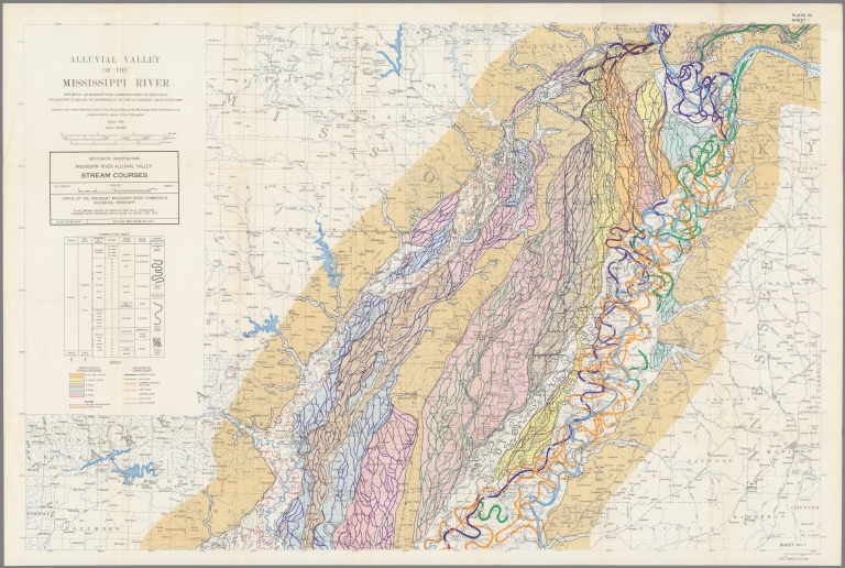
Plate 15 Sheet 1 Alluvial Valley of the Mississippi River. Stream Courses.
Publisher:
Louisiana State University
Publisher Location:
Baton Rouge
Type:
Book Map
Obj Height cm:
98
Obj Width cm:
144
Scale 1:
250,000
State/Province:
Mississippi
State/Province:
Arkansas
State/Province:
Louisiana
Region:
Mississippi River Valley
Subject:
Geology
Subject:
Rivers
Full Title:
Plate 15 Sheet 1 Alluvial Valley of the Mississippi River. Stream Courses.
List No:
15845.014
Series No:
14
Publication Author:
Fisk, Harold N., 1908-1964
Publication Author:
Mississippi River Commission
Pub Date:
1945
Pub Title:
Geological Investigation of the Alluvial Valley of the Lower Mississippi River, conducted for the Mississippi River Commission.
Pub Note:
"While some of the conclusions of the report are outdated, the maps are beautiful and illustrate the dynamic history of the Mississippi River. The most striking are the 15 sheets that make up Plate 22, the meander maps of the Mississippi from Cape Girardeau to Donaldsonville." (LSU web site). 78 plates, maps, tables, diagrs. and atlas of 27 folding maps. The Rumsey collection has about half of the 27 maps and plates. The other half have been downloaded from the biotect.law.lsu.edu site, with thanks. Stanford Library has a complete physical copy, see https://searchworks…
Pub List No:
15845.000
Pub Type:
Geology Book
Pub Maps:
27
Pub Height cm:
31
Pub Width cm:
20
Image No:
15845014.jp2
Authors:
Fisk, Harold N., 1908-1964; Mississippi River Commission