COLLECTION NAME:
David Rumsey Historical Map Collection
Record
Author:
Survey of India Department
Date:
1895
Short Title:
Land revenue systems of British India and Mysore.
Publisher:
India. Superintendent of Government Printing
Publisher Location:
Calcutta
Type:
Atlas Map
Obj Height cm:
26
Obj Width cm:
31
Scale 1:
12,165,120
Note:
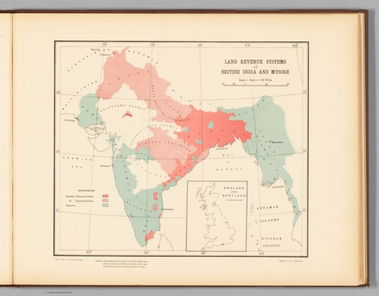
Lithographed map of India, illustrating land revenue systems of British India and Mysore (specifying permanently and temporarily settled areas), with color coding. Map shows regions, as well as major cities, bays, seas, islands, and the boundaries of adjacent countries. Includes a legend and explanatory note, as well as latitudinal and longitudinal lines, a bar scale and scale statement: Scale 1 inch = 192 miles. With inset map: England and Scotland on the same scale. 26 x 31 cm, on sheet 34 x 43 cm.
Country:
India
City:
Mysuru (India)
Subject:
Statistical
Subject:
Land Development
Full Title:
Land revenue systems of British India and Mysore. Reg. No. 404, R. & A. Dept. - Aug. 94 - 2,016. Litho., S. I. O., Calcutta.
List No:
14252.060
Series No:
60
Engraver or Printer:
India. Superintendent of Government Printing
Engraver or Printer:
Survey of India Office
Publication Author:
Survey of India Department
Pub Date:
1895
Pub Title:
Statistical atlas of India. (Second edition, 1895.) Calcutta: Printed by the Superintendent of Government Printing, India. Maps by the Survey of India Department, 1895.
Pub Note:
Statistical atlas of India (second edition) by the Survey of India Department, published in 1895 by the Superintendent of Government Printing, India. Collation: [74] pages, [35] plates with 51 individual maps and 30 individual diagrams. Maps and diagrams illustrate a variety of data described in nineteen chapters. Topics include topography, geology, vegetation, agriculture, commerce, culture, education, migration, and political boundaries, including the distinction between British provinces and native states within India. Maps appear in color and were created by lithographic, zincographic and photolithographic printing processes.
Pub List No:
14252.000
Pub Type:
National Atlas
Pub Type:
Statistical Atlas
Pub Maps:
35
Pub Height cm:
35
Pub Width cm:
45
Image No:
14252060.jp2
Authors:
Survey of India Department