COLLECTION NAME:
David Rumsey Historical Map Collection
Record
Author:
Gutiérrez, Tonatiúh, 1929-
Author:
Mexico. Secretaría de Industria y Comercio
Author:
Mexico. Comisión Nacional Consultiva de Pesca
Author:
Instituto Nacional de Investigaciones Biológico Pesqueras (Mexico)
Author:
Mexico. Dirección General de Pesca e Industrias Conexas
Date:
1965
Short Title:
Colima.
Publisher:
Mexico. Secretaría de Industria y Comercio
Publisher Location:
Mexico
Type:
Atlas Map
Type:
Diagram
Obj Height cm:
21
Obj Width cm:
25
Note:
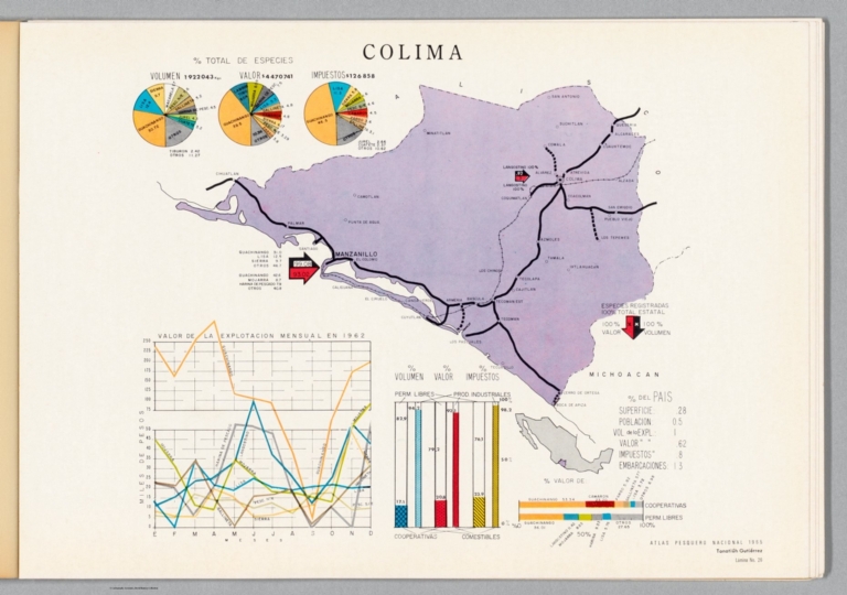
Colored map of Colima (Mexico) representing the fishing industry. Map shows political borders, coastlines, routes and fishing industry locations. Includes a legend. With an index map indicating the location of Colima within Mexico. Also, with various charts, including: Valor de la explotacion mensual en 1962 [= Value of monthly exploitation in 1962] -- % total de especies [= Percentage of total species] -- % del país [= Percentage of the country]. Map is 21 x 25 cm; atlas opened to double page 24 x 68 cm. Accompanied by a collage of black and white photographs showing coins, fish and fishing vessels on preceding plate. Facing page - interleaved between map and collage - contains accompanying descriptive text on transparent paper, through which one can see a partial view of the collage. Text begins: Pequesa entidad del país, que representa únicamente el 0.28% de la superficie nacional y el 0.5% de su población; se localiza en el litoral del Pacífico, dentro de la II zona pesquera, y cuenta con 114 km. de litoral y 1543 km² de plataforma continental ... [= Small region of the country, which represents only 0.28% of the national surface and 0.5% of its population; It is located on the Pacific coast, within the II fishing zone, and has 114 km. of coastline and 1,543 km² of continental shelf ... ].
Country:
Mexico
Region:
Colima (Mexico : State)
Subject:
Fishing
Subject:
Data Visualization
Full Title:
Colima. Atlas pesquero nacional, 1965, Tonatiúh Gutiérrez. Lámina No. 26.
List No:
14303.059
Page No:
26
Series No:
59
Engraver or Printer:
Offset Publicitario Mexico
Publication Author:
Gutiérrez, Tonatiúh, 1929-
Publication Author:
Mexico. Secretaría de Industria y Comercio
Publication Author:
Mexico. Comisión Nacional Consultiva de Pesca
Publication Author:
Instituto Nacional de Investigaciones Biológico Pesqueras (Mexico)
Publication Author:
Mexico. Dirección General de Pesca e Industrias Conexas
Pub Date:
1965
Pub Title:
Atlas pesquero nacional. Tonatiuh Gutierrez. México, 1965. Secretaría de Industria y Comercio, Comisión Nacional Consultiva de Pesca, Instituto Nacional de Investigaciones Biológico Pesqueras, Dirección General de Pesca e Industrias Conexas.
Pub Note:
Atlas pesquero nacional by Tonatiúh Gutiérrez, published in Mexico, 1965. Title translates to: National fishing atlas. Bound in paper; perfect binding. Front cover decorated with a painting of underwater scenery, La conquista de nuestros recursos marinos [= The conquest of our marine resources], by Eleazar Molina. Printed by Offset Publicitario Mexico, S.A. (credid provided in both colophon on final page and on back cover). Collation: [8] pages, 40 leaves, 40 leaves of double-sided plates. Plates comprised of 22 maps, 18 charts and 40 collages of black and white photographs. Maps show political borders, coastlines, water routes and the locations of the fishing industry, including both fishing and fish processing. Maps accompanied by charts used to convey geographic information through data visualization. Each double-sided plate includes, on the side opposite the maps and charts, a collage of black and white photographs illustrating the fishing industry of Mexico. In addition, interleaved between the pairs of collages and maps/charts, are transparent sheets printed with descriptive text. The transparency allows for a partial view of either the collage or map, depending upon which way it is turned. Atlas includes an introduction and table of contents, as well as a quotation from the President of Mexico, at the time of publication, Gustavo Díaz Ordáz. All together, the maps, charts and photographs synthesize into a dynamic atlas the covers the geography, economy and cultural dimensions of fishing in Mexico.
Pub List No:
14303.000
Pub Type:
National Atlas
Pub Type:
Thematic Atlas
Pub Maps:
22
Pub Height cm:
24
Pub Width cm:
34
Image No:
14303059.jp2
Authors:
Gutiérrez, Tonatiúh, 1929-; Mexico. Secretaría de Industria y Comercio; Mexico. Comisión Nacional Consultiva de Pesca; Instituto Nacional de Investigaciones Biológico Pesqueras (Mexico); Mexico. Dirección General de Pesca e Industrias Conexas