COLLECTION NAME:
David Rumsey Historical Map Collection
Record
Author:
Lake, D. J.
Date:
1874
Short Title:
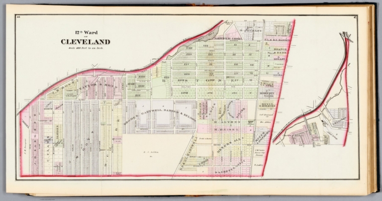
12th Ward of Cleveland.
Publisher:
Titus, Simmons & Titus
Publisher Location:
Philadelphia
Type:
Atlas Map
Obj Height cm:
36
Obj Width cm:
75
Scale 1:
4,750
Note:
Map of the Twelfth Ward of Cleveland, Ohio. Shows railways, roads, property ownership, and drainage. Includes a scale statement: 400 ft. to an inch. Hand colored engraving. Map is 36 x 75 cm, on fold-out sheet 41 x 78 cm.
City:
Cleveland (Ohio)
Full Title:
12th Ward of Cleveland.
List No:
14483.022
Page No:
46-47
Series No:
22
Engraver or Printer:
Worley & Bracher
Engraver or Printer:
Bourquin, F. (Frederick), 1808-
Publication Author:
Lake, D. J.
Pub Date:
1874
Pub Title:
Atlas of Cuyahoga County Ohio from actual surveys by and under the direction of D.J. Lake, C.E. Assisted by B.N. Griffing, F.L. Hayes. Assisted by C.H. Edwards, J.P. Edwards, A.C. Ferry. Published by Titus, Simmons & Titus 31 South Street. Philadelphiam 1874. Engd by Worley & Bracher, 31 Sth Sixth St. Philadelphia. Printed by Fred Bourquin, 29 & 31 Sth Sixth St. Philada.
Pub Note:
Atlas of Cuyahoga County Ohio, by D.J. Lake; published by Titus, Simmons and Titus in Philadelphia, 1874. Tall folio, bound in original Morocco-backed boards. Includes a title page and table of contents. Atlas comprised of 55 maps (plus 24 ancillary maps throughout) and 129 individual views on 100 plates. The first half of the atlas represents the city of Cleveland, showing its various wards and the homes of prosperous residents. The second half presents towns and villages surrounding Cleveland. Maps show railways, roads, property ownership, drainage and shorelines, while the views provide pictorial details such as the landscape, architecture, horse-drawn carriages, trolleys, and people. Hand-colored maps engraved by Worley and Bracher, with views lithographed by H.J. Toudy. Many of the townships represented in the volume have since been absorbed into current-day Cleveland, making this a historical document of the previous township boundaries in the area. For further detail, see the following resources: Defunct townships of Cuyahoga County, Ohio. Wikipedia. https://en.wikipedi… Encyclopedia of Cleveland History. Case Western Reserve University. https://case.edu/ec… General History. The Lakewood Historical Society. https://www.lakewoo… Township Histories. Cuyahoga County, Ohio Web Site. https://sites.roots…
Pub List No:
14483.000
Pub Type:
County Atlas
Pub Maps:
55
Pub Height cm:
42
Pub Width cm:
39
Image No:
14483022.jp2
Authors:
Lake, D. J.