COLLECTION NAME:
David Rumsey Historical Map Collection
Record
Author:
Geological Survey (U.S.)
Author:
Conant, Louis C.
Author:
Goudarzi, Gus H.
Date:
1964
Short Title:
Geologic map of the Kingdom of Libya = خريطة جيولوجية للمملكة الليبية = Kharīṭah jiyūlūjīyah lil-Mamlakah al-Lībyah
Publisher:
Interior- Geological Survey
Publisher Location:
Washington, D. C.
Type:
Separate Map
Obj Height cm:
92
Obj Width cm:
120
Scale 1:
2,000,000
Note:
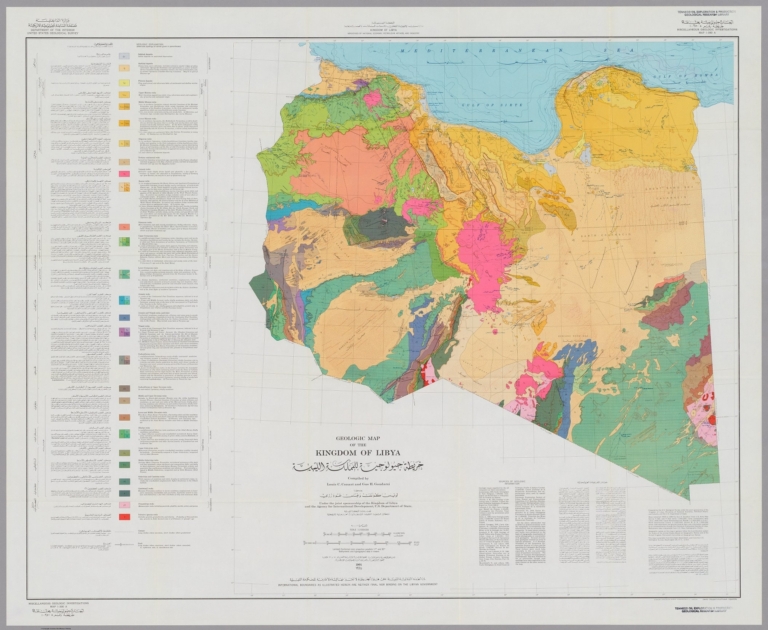
Color geological map of Libya. Published by the U.S. Geological Survey, Washington, D.C., 1964.
Country:
Libya
Subject:
Physical
Subject:
Geology
Full Title:
Geologic map of the Kingdom of Libya = خريطة جيولوجية للمملكة الليبية = Kharīṭah jiyūlūjīyah lil-Mamlakah al-Lībyah. Compiled by Louis C. Conant and Gus H. Goudarzi under the joint sponsership of the Kingdom of Libya and the Agency for International Development, U. S. Department of State. 1964. Department of Interior, United States Geological Survey. Kingdom of Libya. Ministries of National Economy, Petroleum Affairs, and Industry. Miscellaneous Geological Investigations, Map 1-350 A.
List No:
13541.002
Series No:
2
Engraver or Printer:
Libya. Wizārat al-Iqtiṣād al-Waṭanī.
Engraver or Printer:
United States. Agency for International Development.
Publication Author:
Geological Survey (U.S.)
Publication Author:
Conant, Louis C.
Publication Author:
Goudarzi, Gus H.
Pub Date:
1964
Pub Title:
Geologic map of the Kingdom of Libya = خريطة جيولوجية للمملكة الليبية = Kharīṭah jiyūlūjīyah lil-Mamlakah al-Lībyah. Compiled by Louis C. Conant and Gus H. Goudarzi under the joint sponsership of the Kingdom of Libya and the Agency for International Development, U. S. Department of State. 1964. Department of Interior, United States Geological Survey. Kingdom of Libya. Ministries of National Economy, Petroleum Affairs, and Industry. Miscellaneous Geological Investigations, Map 1-350 A.
Pub Note:
Geologic map of Libya, on sheet 92x120, folded into an envelope 30x23.5. Published by the U.S. Geological Survey, Washington, D.C., 1964. In English and Arabic. Lambert conformal conic projection. Shows international boundaries, physical features, and rocks formations. Include geologic time table and Sources of geologic information. Relief shown by contours, hachures, and spot heights. Bathymetric and hypsographic data in meters.
Pub List No:
13541.000
Pub Type:
Case Map
Pub Height cm:
30
Pub Width cm:
24
Image No:
13541002.jp2
Authors:
Geological Survey (U.S.); Conant, Louis C.; Goudarzi, Gus H.