|
Author
Rennell, James, 1742-1830
Full Title
Map of the Cossimbuzar Island (with) Battle of Plassey... 1757
List No
16229.017
Author
[Kendall, George Wilkins, Nebel, Carl]
Full Title
Map of the Operations of the American Army in the Valley of Mexico In August and September 1847.
List No
16185.003
Author
[Neurath, Otto, 1882-1945, Arntz, Gerd, 1900-1988]
Full Title
Die kämpfenden des Weltkriegs 1914-18.
List No
14519.026
Note
Map representing the number of combatants in World War I in Europe from 1914 to 1918. Population represented by country. Map shows political boundaries and coastlines. Color lithograph. Map is 15 x 21 cm, on sheet 15 x 21 cm.
Author
Bacler d'Albe, Louis-Albert-Ghislain, 1761-1824
Full Title
Feuille No. XXVI Carte Générale du théâtre de la guerre en Italie et dans les Alpes
List No
15716.002
Author
Bacler d'Albe, Louis-Albert-Ghislain, 1761-1824
Full Title
Petit Tableau d'Assemblage de la Carte Générale du théâtre de la guerre en Italie.
List No
15716.003
Author
Bacler d'Albe, Louis-Albert-Ghislain, 1761-1824
Full Title
Feuille No. I (with) Feuille No. VI Carte Générale du théâtre de la guerre en Italie et dans les Alpes
List No
15716.004
Author
Bacler d'Albe, Louis-Albert-Ghislain, 1761-1824
Full Title
Feuille No. XI (with) Feuille No. XVI Carte Générale du théâtre de la guerre en Italie et dans les Alpes
List No
15716.005
Author
Bacler d'Albe, Louis-Albert-Ghislain, 1761-1824
Full Title
Feuille No. XXI Carte Générale du théâtre de la guerre en Italie et dans les Alpes
List No
15716.006
Author
Bacler d'Albe, Louis-Albert-Ghislain, 1761-1824
Full Title
Feuille No. II (with) Feuille No. VII Carte Générale du théâtre de la guerre en Italie et dans les Alpes
List No
15716.007
Author
Bacler d'Albe, Louis-Albert-Ghislain, 1761-1824
Full Title
Feuille No. XII (with) Feuille No. XVII Carte Générale du théâtre de la guerre en Italie et dans les Alpes
List No
15716.008
Author
Bacler d'Albe, Louis-Albert-Ghislain, 1761-1824
Full Title
Feuille No. XXII (with) Feuille No. XXVII Carte Générale du théâtre de la guerre en Italie et dans les Alpes
List No
15716.009
Author
Bacler d'Albe, Louis-Albert-Ghislain, 1761-1824
Full Title
Feuille No. III (with) Feuille No. VIII Carte Générale du théâtre de la guerre en Italie et dans les Alpes
List No
15716.010
Author
Bacler d'Albe, Louis-Albert-Ghislain, 1761-1824
Full Title
Feuille No. XIII (with) Feuille No. XVIII Carte Générale du théâtre de la guerre en Italie et dans les Alpes
List No
15716.011
Author
Bacler d'Albe, Louis-Albert-Ghislain, 1761-1824
Full Title
Feuille No. XXIII (with) Feuille No. XXVIII Carte Générale du théâtre de la guerre en Italie et dans les Alpes
List No
15716.012
Author
Bacler d'Albe, Louis-Albert-Ghislain, 1761-1824
Full Title
Feuille No. IV (with) Feuille No. IX Carte Générale du théâtre de la guerre en Italie et dans les Alpes
List No
15716.013
Author
Bacler d'Albe, Louis-Albert-Ghislain, 1761-1824
Full Title
Feuille No. XIV (with) Feuille No. XIX Carte Générale du théâtre de la guerre en Italie et dans les Alpes
List No
15716.014
Author
Bacler d'Albe, Louis-Albert-Ghislain, 1761-1824
Full Title
Feuille No. XXIV (with) Feuille No. XXIX Carte Générale du théâtre de la guerre en Italie et dans les Alpes
List No
15716.015
Author
Bacler d'Albe, Louis-Albert-Ghislain, 1761-1824
Full Title
Feuille No. V (with) Feuille No. X Carte Générale du théâtre de la guerre en Italie et dans les Alpes
List No
15716.016
Author
Bacler d'Albe, Louis-Albert-Ghislain, 1761-1824
Full Title
Feuille No. XV (with) Feuille No. XX Carte Générale du théâtre de la guerre en Italie et dans les Alpes
List No
15716.017
Author
Bacler d'Albe, Louis-Albert-Ghislain, 1761-1824
Full Title
Feuille No. (XXV) La Grece Ancienne, et Moderne ou Carte Generale (with) Feuille No. XXX Abrege Historique Carte Générale du théâtre de la guerre en Italie et dans les Alpes
List No
15716.018
Note
Sheet XXX has been updated to add campaigns of 1799 in a sixth column of text.
Author
Bacler d'Albe, Louis-Albert-Ghislain, 1761-1824
Full Title
Feuille No. 1 Carte Générale des Royaumes de Naples, Sicile & Sardaigne
List No
15716.020
Author
Bacler d'Albe, Louis-Albert-Ghislain, 1761-1824
Full Title
Tableau D'Assemblage (with) Canevas Generale Carte générale des Royaumes de Naples, Sicile & Sardaigne
List No
15716.021
Author
Bacler d'Albe, Louis-Albert-Ghislain, 1761-1824
Full Title
Feuille No. 4 (with) Feuille No. 5 Carte Générale des Royaumes de Naples, Sicile & Sardaigne
List No
15716.022
Author
Bacler d'Albe, Louis-Albert-Ghislain, 1761-1824
Full Title
Feuille No.12 (with) Feuille No. 13 Carte Générale des Royaumes de Naples, Sicile & Sardaigne
List No
15716.023
Author
Bacler d'Albe, Louis-Albert-Ghislain, 1761-1824
Full Title
Feuille No.20 (with) Feuille No. 21 Carte Générale des Royaumes de Naples, Sicile & Sardaigne
List No
15716.024
Author
Bacler d'Albe, Louis-Albert-Ghislain, 1761-1824
Full Title
Feuille No.3 (with) Feuille No. 6 Carte Générale des Royaumes de Naples, Sicile & Sardaigne
List No
15716.025
Author
Bacler d'Albe, Louis-Albert-Ghislain, 1761-1824
Full Title
Feuille No.11 (with) Feuille No. 14 Carte Générale des Royaumes de Naples, Sicile & Sardaigne
List No
15716.026
Author
Bacler d'Albe, Louis-Albert-Ghislain, 1761-1824
Full Title
Feuille No.19 (with) Feuille No. 22 Carte Générale des Royaumes de Naples, Sicile & Sardaigne
List No
15716.027
Author
Bacler d'Albe, Louis-Albert-Ghislain, 1761-1824
Full Title
Feuille No. 2 (with) Feuille No. 7 Carte Générale des Royaumes de Naples, Sicile & Sardaigne
List No
15716.028
Author
Bacler d'Albe, Louis-Albert-Ghislain, 1761-1824
Full Title
Feuille No. 10 (with) Feuille No. 15 Carte Générale des Royaumes de Naples, Sicile & Sardaigne
List No
15716.029
Author
Bacler d'Albe, Louis-Albert-Ghislain, 1761-1824
Full Title
Feuille No. 18 (with) Feuille No. 23 Carte Générale des Royaumes de Naples, Sicile & Sardaigne
List No
15716.030
Author
Bacler d'Albe, Louis-Albert-Ghislain, 1761-1824
Full Title
Feuille No. 8 Carte Générale des Royaumes de Naples, Sicile & Sardaigne
List No
15716.031
Author
Bacler d'Albe, Louis-Albert-Ghislain, 1761-1824
Full Title
Feuille No. 9 (with) Feuille No. 16 Carte Générale des Royaumes de Naples, Sicile & Sardaigne
List No
15716.032
Note
Feuille 16 includes top third of Carte Generale du Royaume Sardaigne
Author
Bacler d'Albe, Louis-Albert-Ghislain, 1761-1824
Full Title
Feuille No.17 (with) Feuille No. 24 Carte Générale des Royaumes de Naples, Sicile & Sardaigne
List No
15716.033
Note
Feuilles 17 and 24 include the bottom two thirds of Carte Generale du Royaume Sardaigne
Author
Radó, Sándor, 1899-1981
Full Title
Der Weltkrieg (1914-1918).
List No
14253.014
Note
Political world map, in color, showing international boundaries during World War I, distinguishing the Central Powers, Allied Powers, and neutral states. Includes a legend, as well as a text box decoding abbreviations, such as "T." for "Türkei". Title in lower margin; translates to: The World War (1914-1918). 20 x 30 cm, on sheet 26 x 34 cm. Accompanied by descriptive text on facing page.
Author
Radó, Sándor, 1899-1981
Full Title
Das Rüsten zum Nächsten Krieg.
List No
14253.026
Note
Political world map, in color, showing military preparations for the next World War, quantifying manpower and weaponry. Includes a legend, as well as a text box decoding abbreviations, such as "R." for "Rumanien". Title in lower margin; translates to: Preparing for the next war. 20 x 30 cm, on sheet 26 x 34 cm. Accompanied by descriptive text on facing page.
Author
Andriveau-Goujon, E. (Eugène), 1832-1897
Full Title
(20) Algérie d'après les cartes de l'état-major et les documents du Ministère de la Guerre. E. Andriveau-Goujon, éditeur. Paris, Rue du Bac, 4, 1880. Paris, Impie. Alfred Chardon jeune; Gravée par Ms. Gérin; Dalmont, Smith et Fontaine.
List No
14008.024
Note
Hand-colored, engraved map of Algeria and greater North Africa, showing showing political boundaries, roads, railroads, water routes and military divisions (on double plate with decorative border). Includes legend, as well as 2 bar scales and a scale statement. "No. 21" in upper right. "Atlas usuel, No. 28" and "Atlas universel, No. 41" in lower right. With inset (indexed to show colonies): Carte d'Ensemble des rapports entre la France, l'Algérie, la Sénégambie et le Nord de l'Afrique.
Author
[Instituto de Geografía (Academia de Ciencias de Cuba), Akademiia nauk SSSR. Institut geografii.]
Full Title
Luchas armadas del pueblo Cubano por su independencia, 1868-1898. Sublevaciones armadas y Luchas en la Republica mediatzada, 1902-1952. Atlas nacional de Cuba : en el decimo aniversario de la Revolucion. La Habana 1970.
List No
13566.101
Note
2 maps on 1 sheet, with insets: Batalla de Santiago de Cuba, 188; La Habana. Maps showing armed uprising and struggles of the Cuban people for their independence.
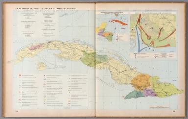
Author
[Instituto de Geografía (Academia de Ciencias de Cuba), Akademiia nauk SSSR. Institut geografii.]
Full Title
Luchas armadas del pueblo Cuba por su liberacion, 1953-1958. Atlas nacional de Cuba : en el decimo aniversario de la Revolucion. La Habana 1970.
List No
13566.102
Note
Map of Cuba, with insets: Movimientos contrarrevolucionarios previos al ataque a playa Giron (1961); Derrota del ataque contrarrevolucionario en Playa Giron, (1961). Showing Armed struggles of the Cuban people for their liberation, the battle fields, the attack by land, sea and air and defeat of the counterrevolutionary attack in Playa Giron.
Author
[United States. Office of War Information, United States. Army. Western Defense Command, United States. Wartime Civil Control Administration]
Full Title
Geographical distribution : Japanese population, United States : 1940. Western Defense Command and Fourth Army, Wartime Civil Control Administration.
List No
14375.026
Note
Map of the United States, featuring the geographical distribution of the Japanese American population in the United States in 1940. Shows political boundaries and the number of Japanese Americans in each state, utilizing data visualization to illustrate population density. Includes explanatory note. In color. Map is 15 x 23 cm. Figure 5-b. Appears in Part IV : Evacuation - its operational technique, Chapter VIII : Development and execution of the evacuation plan. (Page number inferred.)
Author
[United States. Office of War Information, United States. Army. Western Defense Command, United States. Wartime Civil Control Administration]
Full Title
Japanese population : Western defense command area : 1940. Western Defense Command and Fourth Army, Wartime Civil Control Administration.
List No
14375.027
Note
Map of the western United States, featuring the Japanese population in the Western Defense Command Area in 1940. Shows political boundaries and the approximate number of Japanese Americans in each state, utilizing data visualization to illustrate population density. Includes a legend. With four inset maps: Seattle metropolitan area -- Portland metropolitan area -- San Francisco Bay Area -- Los Angeles metropolitan area. Black and white. Map is 14 x 12 cm, on sheet 23 x 15 cm. "Source: U. S. Bureau of the Census." Figure 6. Appears in Part IV : Evacuation - its operational technique, Chapter VIII : Development and execution of the evacuation plan.
Author
[United States. Office of War Information, United States. Army. Western Defense Command, United States. Wartime Civil Control Administration]
Full Title
Exclusion areas : Japanese evacuation program. Western Defense Command and Fourth Army, Wartime Civil Control Administration.
List No
14375.030
Note
Map of the western United States, featuring the exclusion areas during the evacuation of the Japanese population from the Pacific Coast. Shows political boundaries and the assembly and relocation centers. Includes a legend. With four inset maps: Seattle and vicinity -- Portland and vicinity -- San Francisco and vicinity -- Los Angeles and vicinity. Black and white. Map is 15 x 12 cm, on sheet 23 x 15 cm. Figure 9. Appears in Part IV : Evacuation - its operational technique, Chapter VIII : Development and execution of the evacuation plan.
Author
[United States. Office of War Information, United States. Army. Western Defense Command, United States. Wartime Civil Control Administration]
Full Title
Net voluntary movement of Japanese : Western Defense Command Area, March 12th to June 5th, 1942. Western Defense Command and Fourth Army, Wartime Civil Control Administration.
List No
14375.033
Note
Map of the United States, featuring the allegedly voluntary migration of Japanese Americans in the Western Defense Command Area, from March 12th to June 5th, 1942. Shows political boundaries and utilizes data visualization to illustrate population density within the migration to different places. Includes a legend and explanatory note. Black and white. Map is 11 x 16 cm, on sheet 15 x 23 cm. Figure 11. Appears in Part IV : Evacuation - its operational technique, Chapter IX : Voluntary migration.
Author
United States. Office of War Information
Full Title
Assembly center sites.
List No
14375.042
Note
Map featuring assembly center sites in the western United States. Shows political boundaries, cities, roads, national parks, bodies of water, drainage and coastline. Includes a table: Maximum Japanese population and dates of occupation of assembly centers. In color. Map is 28 x 19 cm, on double sheet 31 x 23 cm. Figure 15. Appears in Part V : Assembly center operations, Chapter XIII : Assembly center location, construction and equipment.
Author
United States. Office of War Information
Full Title
Location of assembly center : Tanforan.
List No
14375.043
Note
Map featuring the assembly center location in Tanforan of San Bruno, California. Shows the vicinity's political boundaries, cities, railways, roads, topography, bodies of water and drainage. Relief shown with hachures and spot heights. Includes a legend, explanatory notes and bar scale given in miles. In color. Map is 14 x 11 cm, on sheet 23 x 15 cm. Figure 14-f. Appears in Part V : Assembly center operations, Chapter XIII : Assembly center location, construction and equipment.
Author
United States. Office of War Information
Full Title
War relocation project sites.
List No
14375.076
Note
Map of the United States featuring the war relocation project sites. Shows political boundaries, cities and roads. Includes a legend. In color. Map is 14 x 18 cm, on sheet 15 x 23 cm. Figure 21. With descriptive text on facing page. Appears in Part VI : Relocation of evacuees, Chapter XXI : The construction and equipment of relocation centers.
Author
United States. Office of War Information
Full Title
Location of war relocation center : Manzanar.
List No
14375.078
Note
Map featuring the war relocation center in Manzanar of Owens Valley, California. Shows the vicinity's political boundaries, cities, railways, roads, topography, bodies of water and drainage. Relief shown with hachures. Includes a legend, explanatory notes and bar scale given in miles. In color. Map is 14 x 9 cm, on sheet 23 x 15 cm. Figure 20-g. Appears in Part VI : Relocation of evacuees, Chapter XXI : The construction and equipment of relocation centers.
Author
[United States. Office of War Information, United States. Army. Western Defense Command, United States. Wartime Civil Control Administration]
Full Title
Japanese evacuation program : Exclusion areas. Western Defense Command and Fourth Army, Wartime Civil Control Administration, Statistical Division.
List No
14375.090
Note
Map of the western United States, featuring the "exclusion areas" for Japanese Americans during World War II. Shows political boundaries, assembly and relocation centers, bodies of water, coastline and islands. Includes a legend and explanatory note. With four inset maps: Seattle and vicinity -- Portland and vicinity -- San Francisco and vicinity -- Los Angeles and vicinity -- Sacramento and vicinity. In color. Map is 32 x 32 cm, on fold-out sheet 45 x 36 cm. Figure 27. Appears in Part VI : Relocation of evacuees, Chapter XXII : Transfer of evacuees from assembly to relocation centers.
Author
[United States. Office of War Information, United States. Army. Western Defense Command, United States. Wartime Civil Control Administration]
Full Title
Japanese evacuation program : Assembly center destinations. Western Defense Command and Fourth Army, Wartime Civil Control Administration, Statistical Division.
List No
14375.091
Note
Map of the western United States, featuring the assembly center destinations for Japanese Americans during World War II. Shows political boundaries, assembly and relocation centers, bodies of water, coastline and islands. Includes a legend and explanatory note. With five inset maps: Seattle and vicinity -- Portland and vicinity -- San Francisco and vicinity -- Los Angeles and vicinity -- Sacramento and vicinity. In color. Map is 32 x 32 cm, on fold-out sheet 45 x 36 cm. Figure 27. Appears in Part VI : Relocation of evacuees, Chapter XXII : Transfer of evacuees from assembly to relocation centers.
Author
[United States. Office of War Information, United States. Army. Western Defense Command, United States. Wartime Civil Control Administration]
Full Title
Japanese evacuation program : Relocation center destinations. Western Defense Command and Fourth Army, Wartime Civil Control Administration, Statistical Division.
List No
14375.092
Note
Map of the western United States, featuring the relocation center destinations for Japanese Americans during World War II. Shows political boundaries, assembly and relocation centers, bodies of water, coastline and islands. Includes a legend and explanatory note. With five inset maps: Seattle and vicinity -- Portland and vicinity -- San Francisco and vicinity -- Los Angeles and vicinity -- Sacramento and vicinity. In color. Map is 32 x 32 cm, on fold-out sheet 45 x 36 cm. Figure 27. Appears in Part VI : Relocation of evacuees, Chapter XXII : Transfer of evacuees from assembly to relocation centers.
|