Who What Where WhenREMOVEWHATShow More |
Author
Depot General de la Marine
Full Title
Carte Reduite Des Mers Du Nord
List No
15934.003
Note
Hydrographie Française 1
Author
[Aitken, Robert, Simitiere, Pierre]
Full Title
Map of the Maritime Parts of Virginia Exhibiting the Seat of War and of Ld. Dunmore's depredations in that Colony.
List No
15852.000
Author
Lopez de Vargas Machuca, Tomas (1730-1802)
Full Title
Mapa del principado de Cataluna ... Por D. Thomas Lopez y Vargas ... 1776
List No
15570.005
Note
Engraved outline hand colored map with title carthouche. Shows administrative divisions, major cities, towns, villages, landmarks, public buildings, roads, rivers, canals, forests and mountains. Relief shown pictorially and by hachures. Prime meridian is Tenerife. Includes explanation to symbols, descriptive text, and key to convents and monasteries.
Author
Cook, James, active 1762-1775
Full Title
Chart of the entrance of Hudson's River, from Sandy Hook to New York, with the banks, depths of water, sailing-marks, &ca. London. Printed for Robt. Sayer & John Bennett, Sea Chart & Map-sellers, No. 53, in Fleet Street. Published as the Act directs. 1st. June 1776.
List No
14471.035
Note
Nautical chart of the Hudson River, New Jersey and New York, in 1776. Shows cities, topography, vegetation, bodies of water, drainage, coastlines, ports, bays, anchorage, shoals, islands, rocks and depths, given in fathoms. Relief shown with hachures. With arrows indicating the direction of water currents. Includes rhumb lines, a bar scale given in miles and a compass rose with north oriented toward top of sheet. With explanatory text and descriptive notes throughout. Black and white copper-engraving. Chart is 70 x 52 cm, on double plate 73 x 55 cm. Chart appears in second volume of atlas.
Author
[Cook, James, active 1762-1775, Fisher, Joshua, 1707-1783]
Full Title
A chart of Delaware Bay and River, containing a full and exact description of the shores, creeks, harbours, soundings, shoals, sands, and bearings of the most considerable land marks, &c. &c. Faithfully coppied from that published at Philadelphia. By Joshua Fisher, together with the tide table from the Capes to Philadelphia, and the set of the tide on the several quarters of the flood and ebb. London. Printed for Robt. Sayer & Jh. Bennett, Map & Sea Chart sellers No. 53, Fleet Street, as the Act directs. 10th. July 1776.
List No
14471.036
Note
Nautical chart of the Delaware Bay and River, Delaware, in 1776. Shows cities, topography, vegetation, bodies of water, drainage, coastlines, ports, bays, anchorage, shoals, islands, rocks and depths, given in fathoms. Relief shown with hachures. Includes rhumb lines and a bar scale given in miles. With descriptive notes throughout. Also, with a "Tide-Table" and a list of pilots and masters of vessels. Black and white copper-engraving. Chart is 47 x 68 cm, on double plate 55 x 73 cm. Chart appears in second volume of atlas.
Author
Cook, James, active 1762-1775
Full Title
A plan of Cape Fear River from the Bar to Brunswick. London. Printed for R. Sayer & J. Bennett, Map & Sea Chart sellers, No. 53 in Fleet Street. Published as the Act directs. 1st. July 1776.
List No
14471.040
Note
Nautical chart of the Cape Fear River, North Carolina, in 1776. Shows cities, topography, vegetation, bodies of water, drainage, coastlines, ports, bays, anchorage, shoals, islands, rocks and depths, given in fathoms. Relief shown with hachures. With arrows indicating the direction of ocean currents. Includes rhumb lines, latitudinal and longitudinal lines, as well as a bar scale given in leagues and a compass rose with north oriented toward top of sheet. With explanatory text and descriptive notes throughout. Black and white copper-engraving. Chart is 51 x 34 cm, on double plate 73 x 55 cm. Chart appears in second volume of atlas.
Author
Cook, James, active 1762-1775
Full Title
An exact plan of Charles-Town-Bar and Harbour. From and actual survey. With the attack of Fort Sulivan, on the 28th of June 1776 by his Majesty's Squadron, commanded by Sir Peter Parker. London. Printed for Robt. Sayer & Jn. Bennett, Map & Sea Chart sellers, No. 53 in Fleet Street, as the Act directs. 31st. August 1776.
List No
14471.041
Note
Nautical chart of the Charleston Harbor, South Carolina, in 1776. Shows cities, topography, vegetation, bodies of water, drainage, coastlines, ports, bays, anchorage, shoals, islands, rocks and depths, given in fathoms. Relief shown with hachures. With arrows indicating the direction of ocean currents. Includes rhumb lines, a bar scale given in miles and a compass rose with north oriented toward right of sheet. Indexed to indicate shipwrecks. With explanatory text and descriptive notes throughout. Black and white copper-engraving. Chart is 50 x 70 cm, on double plate 55 x 73 cm. Chart appears in second volume of atlas.
Author
[Cook, James, active 1762-1775, Gascoigne, John, -1753]
Full Title
A plan of Port Royal in South Carolina. Survey'd by Capn. John Gascoigne. London. Printed for R. Sayer & J. Bennett, Map & Chart-sellers No. 53 Fleet Street, as the Act directs 15 May 1776.
List No
14471.042
Note
Nautical chart of Port Royal Sound, South Carolina, in 1776. Shows cities, topography, vegetation, bodies of water, drainage, coastlines, ports, bays, anchorage, shoals, islands, rocks and depths, given in fathoms. Relief shown with hachures. With arrows indicating the direction of ocean currents. Includes rhumb lines, a bar scale given in miles and a compass rose with north oriented toward top of sheet. With explanatory text and descriptive notes throughout. Black and white copper-engraving. Chart is 62 x 58 cm, on fold-out plate 73 x 61 cm. Chart appears in second volume of atlas.
Author
[Cook, James, active 1762-1775, Gascoigne, John, -1753]
Full Title
A plan of the River and Sound of D'Awfoskee, in South Carolina. Survey'd by Captain John Gascoigne. London. Printed for R. Sayer & J. Bennett, Map & Chart-sellers No. 53 Fleet Street as the Act directs 15 May 1776.
List No
14471.043
Note
Nautical chart of D'Awfoskee Sound, South Carolina, in 1776. Shows cities, topography, vegetation, bodies of water, drainage, coastlines, ports, bays, anchorage, shoals, islands, rocks and depths, given in fathoms. Relief shown with hachures. With arrows indicating the direction of ocean currents. Includes rhumb lines, a bar scale given in miles and a compass rose with north oriented toward top of sheet. With explanatory text and descriptive notes throughout. Cites references. Black and white copper-engraving. Chart is 65 x 45 cm, on double plate 73 x 55 cm. Chart appears in second volume of atlas.
Author
Gautier d'Agoty, J.F. (Jean Fabien), 1717-1785
Full Title
(Title for Volume 1) Journal dédié a Monsieur, frère du Roi. Table generale des journaux anciens et modernes, contenant les jugemens des journalistes sur les principaux ouvrages en tout genre; suivi d'observations impartiales, & de planches en taille-douce ou on couleur. Par une Société de Gens des Lettres ... Septembre, No. 1er. Tome Premier. A Paris, Chez Demonville ... M. DCC. LXXVI.
List No
12495.002
Note
Part of volume 1.
Author
Gautier d'Agoty, J.F. (Jean Fabien), 1717-1785
Full Title
(New England (United States))
List No
12495.008
Note
Part of volume 1. Foldout. This may be one of the earliest color printed maps of North America.
Author
Gautier d'Agoty, J.F. (Jean Fabien), 1717-1785
Full Title
(View) No. 4. Le Cameleon.
List No
12495.011
Note
Part of volume 1. Foldout.
Author
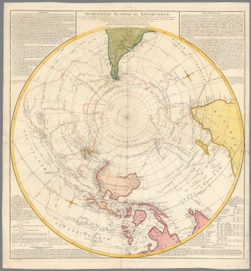
[Robert de Vaugondy, Didier, 1723-1786, Dussy, E.]
Full Title
Hemisphere Austral ou Antarctique projette sur un horizon dont le zenith est situe a 140 degres de longit Orient de l' Isle de Fer et a 66d 32' de latit australe, dressse sous les yeux de M. Le Duc De Croy par le Sr. de Vaugondy, Geographe ord. du Roi, du feu Roi de Pologne Duc de Lorr, et de Bar, de l'Academie Royale des Sciences et Belles-lettres de Nancy et Censeur royal; publie sous l'approbation de l'Academie royale des sciences de 24 Mars 1773 et agmente en 1776 ... Grave par E. Dussy.
List No
11702.000
Note
Hand color in outline circular map of the Southern Hemisphere according to the latest discoveries with the tracks of the Captain James Cook. Showing Cook's tracks of the recent expeditions of Cook and Bouganville on New Zealand, Australia, and the South Pacific. Also showing the routes of modern explorers, such as in 1642 Tasman, Halley in 1700, St. Louis in 1718, Bouvet in 1738, and Cook & Bougainville in 1768. Includes observation notes, table of latitude and longitude and notes.
Author
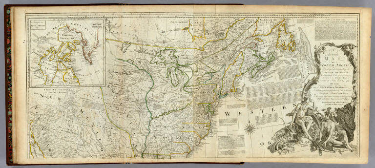
[Pownall, Thomas, 1722-1805, Evans, Lewis, 1700?-1756, Almon, John, 1737-1805, Turner, James, d. 1759, Gist, Christopher, d. 1750]
Full Title
A Map of the Middle British Colonies in North America. First Published by Mr. Lewis Evans, of Philadelphia, in 1755; and since corrected and improved, as also extended with the addition of New England, and bordering Parts of Canada; from actual Surveys now lying at the Board of trade. By T. Pownall MP. Engraved by Jas. Turner in Philadelphia.
List No
6901.002
Note
This is a revised and expanded edition of Lewis Evans' 1755 "Map of the Middle British Colonies in North America." <a href=http://www.davidrumsey.com/luna/servlet/s/7y22vy target=_blank>See in Pownall's "Topographical Description"</a>
Author
Robert Sayer and John Bennett (Firm)
Full Title
(Covers to) The American Military Pocket Atlas; Being An approved Collection of Correct Maps, Both General and Particular, of The British Colonies; Especially those which now are, or probably may be The Theatre of War: Taken principally from the actual Surveys and judicious Observations of Engineers De Brahm and Romans; Cook, Jackson, and Collet; Maj. Holland, and other Officers, Employed in His Majesty's Fleets and Armies. London. Printed for R. Sayer and J. Bennet, Map and Print-Sellers (No. 53) Fleet-street.
List No
0875A
Author
Robert Sayer and John Bennett (Firm)
Full Title
(Title Page to) The American Military Pocket Atlas; Being An approved Collection of Correct Maps, Both General and Particular, of The British Colonies; Especially those which now are, or probably may be The Theatre of War: Taken principally from the actual Surveys and judicious Observations of Engineers De Brahm and Romans; Cook, Jackson, and Collet; Maj. Holland, and other Officers, Employed in His Majesty's Fleets and Armies. London. Printed for R. Sayer and J. Bennet, Map and Print-Sellers (No. 53) Fleet-street.
List No
0875B
Note
This small hand atlas has six early maps, three of which are particularly important to the mapping of the American Revolution: The Seat of War in the Northern Colonies and The seat of War in the Middle British Colonies (both derived from the Evans/Pownall maps), and the Seat of War in the Southern Colonies (by Bernard Romans). Nicknamed the "Holster Atlas" because it was made for the used of British army officers. All maps in outline color, folded and bound into book with paper covered boards and quarter leather with "American Pocket Atlas" stamped in gilt on the spine.
Author
Robert Sayer and John Bennett (Firm)
Full Title
(Text Page in) The American Military Pocket Atlas; Being An approved Collection of Correct Maps, Both General and Particular, of The British Colonies; Especially those which now are, or probably may be The Theatre of War: Taken principally from the actual Surveys and judicious Observations of Engineers De Brahm and Romans; Cook, Jackson, and Collet; Maj. Holland, and other Officers, Employed in His Majesty's Fleets and Armies. London. Printed for R. Sayer and J. Bennet, Map and Print-Sellers (No. 53) Fleet-street.
List No
0875C
Note
Dedication note to Gov. Pownall.
Author
Robert Sayer and John Bennett (Firm)
Full Title
(Text Page in) The American Military Pocket Atlas; Being An approved Collection of Correct Maps, Both General and Particular, of The British Colonies; Especially those which now are, or probably may be The Theatre of War: Taken principally from the actual Surveys and judicious Observations of Engineers De Brahm and Romans; Cook, Jackson, and Collet; Maj. Holland, and other Officers, Employed in His Majesty's Fleets and Armies. London. Printed for R. Sayer and J. Bennet, Map and Print-Sellers (No. 53) Fleet-street.
List No
0875D
Note
Remainder of dedication (left side). Advertisement for the atlas, explaining the contents and intent ("such Maps as an Officer may take with him into the Field...").
Author
Robert Sayer and John Bennett (Firm)
Full Title
(Index Page in) The American Military Pocket Atlas; Being An approved Collection of Correct Maps, Both General and Particular, of The British Colonies; Especially those which now are, or probably may be The Theatre of War: Taken principally from the actual Surveys and judicious Observations of Engineers De Brahm and Romans; Cook, Jackson, and Collet; Maj. Holland, and other Officers, Employed in His Majesty's Fleets and Armies. London. Printed for R. Sayer and J. Bennet, Map and Print-Sellers (No. 53) Fleet-street.
List No
0875E
Note
End of advertisement note. Index to a list of the maps included.
Author
Robert Sayer and John Bennett (Firm)
Full Title
North America, As Divided amongst the European Powers By Samuel Dunn, Mathematician. London: Printed for Robt. Sayer ... 10 Jany. 1774.
List No
0875.001
Note
Map in outline color by European Power.
Author
Robert Sayer and John Bennett (Firm)
Full Title
A Compleat Map of the West Indies, Containing the Coasts of Florida, Louisiana, New Spain, and Terra Firma: with all the Islands. By Samuel Dunn, Mathematician. London: Printed for Robt. Sayer ... 10 January 1774.
List No
0875.002
Note
In outline color by country or European ownership.
Author
Robert Sayer and John Bennett (Firm)
Full Title
A General Map of the Northern British Colonies in America, which comprehends the Province of Quebec, the Government of Newfoundland, Nova-Scotia, New-England and New-York. from the Maps Published by the Admiralty and Board of Trade, Regulated by the Astronomic and Trigonometric Observations of Major Holland, and Corrected from Governor Pownall's Late Map 1776. London: Printed for Robt. Sayer & Jno. Bennett ... 14th August 1776.
List No
0875.003
Note
In outline color. Above the map reads, "The Seat of War, in the Northern Colonies containing the Province of Quebec, Newfoundland, Nova-Scotia, New-England, New-York, New-Jersey, Pennsylvania, &ca."
Author
Robert Sayer and John Bennett (Firm)
Full Title
A General Map of the Middle British Colonies, in America. containing Virginia, Maryland, the Delaware Counties, Pennsylvania and New Jersey. With the addition of New York, and of the Greatest Part of New England, as also of the Bordering Parts of the Province of Quebec, improved from several Surveys made after the late War, and Corrected from Governor Pownall's Late Map 1776. (with) A Sketch of the Upper Parts of Canada. London: Printed for R. Sayer & J. Bennett ... 15th October 1776.
List No
0875.004
Note
In outline color. Above the map reads, "The Seat of War in the Middle British Colonies containing Virginia, Maryland, the Delaware Counties, &ca."
Author
Robert Sayer and John Bennett (Firm)
Full Title
A General Map of the Southern British Colonies, in America. containing North and South Carolina, Georgia, East and West Florida, with the Neighbouring Indian Countries. From the Modern Surveys of Engineer de Brahm, Capt. Collet, Mouzon & Others; and from the Large Hydrographical Survey of the Coasts of East and West Florida. By B. Romans, 1776. (with) Plan of Charleston and ... St. Augustine. London: Printed for R. Sayer & J. Bennett ... 15th Octr. 1776.
List No
0875.005
Note
In outline color. Above the map reads, "The Seat of War in the Southern British Colonies comprehending North and South Carolina, Georgia, East and West Florida, &ca."
Author
Robert Sayer and John Bennett (Firm)
Full Title
A Survey of Lake Champlain, including Lake George, Crown Point and St. John. Surveyed by Order of His Excellency Major-General Sr. Jeffery Amherst, Knight of the most Honble. Order of the Bath, Commander in Chief of His Majesty's Forces in North America, (now Lord Amherst) by William Brassier, Draughtsman. (with) A Particular Plan of Lake George. Surveyed in 1756. By Capt. Jackson. London: Printed for Robt. Sayer & Jno. Bennett ... Augst. 5th 1776.
List No
0875.006
Note
Water in full color with small amounts of outline color.
Author
Jefferys, Thomas
Full Title
(Covers to) The American Atlas: Or, A Geographical Description Of The Whole Continent Of America ... Engraved On Forty-Eight Copper Plates, By The Late Mr. Thomas Jefferys, Geographer to the King, and Others. London, Printed and Sold by R. Sayer and J. Bennett, Map and Print Sellers, No. 53, Fleet-Street. MDCCLXXVI.
List No
0346A
Author
Jefferys, Thomas
Full Title
(Title Page to) The American Atlas: Or, A Geographical Description Of The Whole Continent Of America ... Engraved On Forty-Eight Copper Plates, By The Late Mr. Thomas Jefferys, Geographer to the King, and Others. London, Printed and Sold by R. Sayer and J. Bennett, Map and Print Sellers, No. 53, Fleet-Street. MDCCLXXVI.
List No
0346B
Note
One of the most important atlases of the American Revolutionary War period. There are 22 maps on 29 sheets. The majority of the important large scale maps of the colonies are here, appearing together for the first time after having been issued as separates by Jefferys in the 1750's and 60's. This copy is the 1st 1776 edition, with the Quebec map, without the Lake Champlain map, as issued. This copy is the same as NMM 361, except the title page says 48 copper plates rather then the 49 on NMM 361, and on the NY/NJ map it is Major Holland rather than Capt. Holland (our NY/NJ map says Major-the 1775 says Capt-our index omits Holland-the reproduction atlas map copy says Major, and Carver is eliminated (why?); probably indicates that this was slightly before the NMM 361, as the 1775 title page is identical to this one (although we have not seen it yet-relying on P1165), except for the date. Summary of editions: 1775 (actually issued in 1776, has Evans Middle Colonies map, P1165); 1776 1st issue (our copy with 48 on TP, Quebec replaces Evans, N.Y- & N.J. is dated 1776, rather than 1775 and adds Pownall corrections and improvements); 1776 2nd issue (NMM 361, 49 on TP); 1777 (1776 on TP, N. Amer changes from Bowen/Gibson to Pownall version with 1777 on map, adds L. Champlain, P1166 -our reproduction copy); 1778 (P3659a, NMM 362, no changes from 1777); 1782 (P1169, no changes except Phillips says this copy has 1783 ed of N. Amer., inserted-later?) Our TP is a transition from 1775 to NMM361; NMM361 anticipates the Lake Champlain map in saying 49 plates. Covers are half leather brown cloth covered boards with "Jeffery's American Atlas. London MDCCLXXVI" stamped in gilt on the spine.
Author
Jefferys, Thomas
Full Title
(Index to) The American Atlas: Or, A Geographical Description Of The Whole Continent Of America ... Engraved On Forty-Eight Copper Plates, By The Late Mr. Thomas Jefferys, Geographer to the King, and Others. London, Printed and Sold by R. Sayer and J. Bennett, Map and Print Sellers, No. 53, Fleet-Street. MDCCLXXVI.
List No
0346C
Author
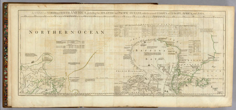
Jefferys, Thomas
Full Title
A Chart of North and South America, including the Atlantic and Pacific Oceans, with the nearest Coasts of Europe, Africa, and Asia. Chart containing part of the Icy Sea with the adjacent Coast of Asia and America. Chart comprizing Greenland with the Countries and Islands about Baffins Bay and part of Hudsons Bay. Publish'd ... 10 June 1775, by Robt. Sayer & J. Bennett ... Fleet Street. No. II.
List No
0346.001
Note
In outline color. Map has extensive notes and charts noting variations in latitudes and longitudes noted by different observations.
Author
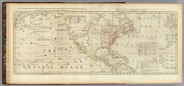
Jefferys, Thomas
Full Title
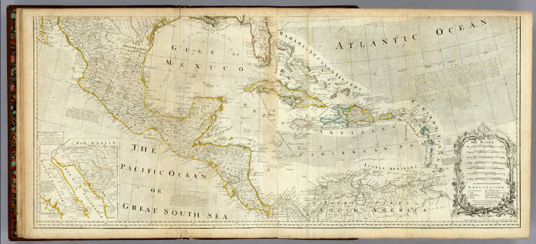
Chart containing the Coasts of California, New Albion, and Russian Discoveries to the North, with the Peninsula of Kamtschatka, in Asia, opposite thereto; And Islands, dispersed over the Pacific Ocean, to the North of the Line. North America and The West Indies, with the opposite Coasts of Europe and Africa. Published ... 10 June 1775, by R. Sayer & J. Bennett ... Fleet Street. IV.
List No
0346.002
Note
In outline color. Map has extensive notes and charts noting variations in latitudes and longitudes noted by different observations. Tracks of the ships in the Pacific Ocean shown along with relevant dates.
Author
Jefferys, Thomas
Full Title
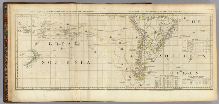
Chart containing the greater part of the South Sea to the South of the Line, with the Islands dispersed thro' the same. South America with the adjacent Islands in the Southern Ocean and South Sea. Published ... 10 June 1775, by R. Sayer & J. Bennett ... Fleet Street. VI.
List No
0346.003
Note
In outline color. Map has extensive notes and charts noting variations in latitudes and longitudes noted by different observations. Tracks of the ships in the oceans shown along with relevant dates.
Author
Jefferys, Thomas
Full Title
(Composite of) A Chart of North and South America, including the Atlantic and Pacific Oceans ... (with) Chart containing the Coasts of California, New Albion, and Russian Discoveries to the North ... (with) Chart containing the greater part of the South Sea to the South of the Line ... Publish'd ... 10 June 1775, by Robt. Sayer & J. Bennett ... Fleet Street. No. II., IV., VI.
List No
0346.004
Note
Map has extensive notes and charts noting variations in latitudes and longitudes noted by different observations. Tracks of the ships in the oceans shown along with relevant dates. In outline color.
Author
Jefferys, Thomas
Full Title
The Russian Discoveries, from the Map Published by the Imperial Academy of St. Petersburg. London, Printed for Robt. Sayer, Map & Printseller, No. 53 in Fleet Street. Published as the Act directs March 2d, 1775.
List No
0346.005
Note
In outline color. Exploration ships' courses shown.
Author
Jefferys, Thomas
Full Title
An Accurate Map Of North America. Describing and distinguishing the British and Spanish Dominions on the great Continent; According to the Definitive Treaty Concluded at Paris 10th Feby. 1763. Also all the West India Islands Belonging to, and possessed by the Several European Princes and States. The whole laid down according to the latest and Most authentick Improvements, By Eman Bowen Gegr: to His Majesty and John Gibson Engraver. (with) A Particular Map of Baffin and Hudson's Bay. London. Printed for Robert Sayer No. 53 Fleet Street as the Act Directs 2d. July 1775.
List No
0346.006
Note
Treaty reproduced along the right side of the large outline color map. Upper half of map shown; lower half bound as next map in Atlas.
Author
Jefferys, Thomas
Full Title
An Accurate Map Of North America. Describing and distinguishing the British and Spanish Dominions on the great Continent; According to the Definitive Treaty Concluded at Paris 10th Feby. 1763. Also all the West India Islands Belonging to, and possessed by the Several European Princes and States. The whole laid down according to the latest and Most authentick Improvements, By Eman Bowen Gegr: to His Majesty and John Gibson Engraver. (with) inset map of The Passage by Land To California, Discovered by Father Eusebius Francis Kino a Jesuit. London. Printed for Robert Sayer No. 53 Fleet Street as the Act Directs 2d. July 1775.
List No
0346.007
Note
In outline color with elaborate cartouche giving seven different scales and an explanation of the symbols used. Article XX of the Treaty is included on this southern section of the map.
Author
Jefferys, Thomas
Full Title
(Composite of) An Accurate Map Of North America. Describing and distinguishing the British and Spanish Dominions on the great Continent; According to the Definitive Treaty Concluded at Paris 10th Feby. 1763. Also all the West India Islands Belonging to, and possessed by the Several European Princes and States. The whole laid down according to the latest and Most authentick Improvements, By Eman Bowen Gegr: to His Majesty and John Gibson Engraver. London. Printed for Robert Sayer No. 53 Fleet Street as the Act Directs 2d. July 1775.
List No
0346.008
Note
In outline color with elaborate cartouche giving seven different scales and an explanation of the symbols used. Treaty reproduced along the right side of the large outline color map.
Author
Jefferys, Thomas
Full Title
North America from the French of Mr. D'Anville Improved with the English Surveys made Since the Peace. London Printed for Robt. Sayer & J. Bennett, Map & Printsellers, No. 53 Fleet Street, as the Act directs 10 June 1775.
List No
0346.009
Note
In outline color stretching from Labrador to Florida.
Author
Jefferys, Thomas
Full Title
A Map Of The British Empire, in North America. By Samuel Dunn, Mathematician, improved from the Surveys of Capt. Carver. London. Printed for R. Sayer & J. Bennett ... Augst. 17th, 1776.
List No
0346.010
Note
In outline color. Small cartouche in upper left-hand corner details the British Empire in North America from the Hudsons Bay Company and Territories to West Florida "which contain all the countries comprehended between the Apalaches, Ohio & Missisipi."
Author
Jefferys, Thomas
Full Title
An Exact Chart of the River St. Laurence, from Fort Frontenac to the Island of Anticosti shewing the Soundings, Rocks, Shoals &c with Views of the Lands and all necessary Instructions for navigating that River to Quebec. To the Rt. Honble. Fn. Montagu El. of Sandwich, First Lord Commisioner to the other Honble. Commissioners for executing the Office of Lord High Admiral of Great Britain. This Chart is most Humbly Inscribed By their Lordships most Obedient most devoted Humble Servt. Thos. Jefferys. (with) Six inset maps [described in notes field]. London. Printed for Robt. Sayer ... 25 May, 1775.
List No
0346.011
Note
Inset map titles: The Seven Islands; A Continuation of the River from Quebec to Lake Ontario Taken from the Original Published at Paris by Mr. D'Anville in 1755; St. Nicholas or English Harbor; A View of the Lands from Cape Torment to the Butt; The Traverse or Passage from Cape Torment into the South Channel of Orleans Island; The Road of Tadousac. Maps in outline color.
Author
Jefferys, Thomas
Full Title
A Chart Of The Gulf Of St. Laurence, Composed From A Great Number Of Actual Surveys And Other Materials, Regulated and Connected by Astronomical Observations. London. Printed & Sold by Robt. Sayer & Jn. Bennett ... 25th March 1775.
List No
0346.012
Note
In outline color. Chart details astronomical observations of latitude, longitude and notes the observer.
Author
[Jefferys, Thomas, Holland, Samuel, 1728-1801]
Full Title
A Map of the Island of St. John In the Gulf of St. Laurence Divided Into Counties & Parishes And the Lots, as granted by Government, to which are added The Soundings round the Coast & Harbours, Improv'd from the late Survey of Captain Holland. Published as the Act direct April 6, 1775. XIII. (with) inset map of the Gulf of St. Laurence.
List No
0346.013
Note
In outline color by Parish. Each Parish divided into numbered lots. Chart above map lists the lots and proprietors' names. Acreage of lots also included in separate chart. Background tinted gray.
Author
Jefferys, Thomas
Full Title
A General Chart Of The Island Of Newfoundland with the Rocks & Soundings. Drawn from Surveys taken by Order of the Right Honourable the Lords Commissioners of the Admiralty. By James Cook and Michael Lane Surveyors and Others. London. Publish'd according to Act of Parliament, 10th May 1775. By Thomas Jefferys Geographer to the King. Printed for Robt. Sayer & Jno. Bennett, No. 53 in Fleet Street.
List No
0346.014
Note
In outline color.
Author
Jefferys, Thomas
Full Title
A Chart Of The Banks Of Newfoundland, Drawn from a Great Number of Hydrographical Surveys, Chiefly from those of Chabert, Cook And Fleurieu, Connected and Ascertained by Astronomical Observations. London. Printed for & Sold by Robt. Sayer & Jno. Bennett ... 25th March 1776.
List No
0346.015
Note
Includes an astronomical chart upon which the map is based. Map in outline color.
Author
Jefferys, Thomas
Full Title
A New Map of Nova Scotia, and Cape Breton Island with the adjacent parts of New England and Canada, Composed from a great number of actual Surveys; and other materials Regulated by many new Astronomical Observations of the Longitude as well as Latitude; by Thomas Jefferys, Geographer to the King. London. Printed & Sold by R. Sayer & J. Bennett ... 15 June 1775.
List No
0346.016
Note
Chart details "Observations on which this Map is Grounded" with latitude and longitude readings as well as the name of the observer. In outline color.
Author
Jefferys, Thomas
Full Title
A Map of the most Inhabited part of New England, containing the Provinces of Massachusetts Bay and New Hampshire, with the Colonies of Conecticut And Rhode Island, Divided into Counties and Townships: The Whole composed from Actual Surveys and its Situation adjusted by Astronomical Observations. (with) A Plan of the Town of Boston. November 29th 1774. Published according to Act by Thos. Jefferys Geographer to His Royal highness the Prince of Wales near Charing Cross. (Northern section)
List No
0346.017
Note
Northern part of map in two sheets. In outline color except for section to the west of the Connecticut River, which is in yellow.
Author
Jefferys, Thomas
Full Title
A Map of the most Inhabited part of New England, containing the Provinces of Massachusetts Bay and New Hampshire, with the Colonies of Conecticut And Rhode Island, Divided into Counties and Townships: The Whole composed from Actual Surveys and its Situation adjusted by Astronomical Observations. (with) A Plan of Boston Harbor from an Accurate Survey. November 29th 1774. Published according to Act by Thos. Jefferys Geographer to His Royal highness the Prince of Wales near Charing Cross. (Southern section)
List No
0346.018
Note
Southern part of map in two sheets. In outline color. Cartouche includes large drawing of the pilgrims landing at Plymouth Rock.
Author
Jefferys, Thomas
Full Title
(Composite of) A Map of the most Inhabited part of New England, containing the Provinces of Massachusetts Bay and New Hampshire, with the Colonies of Conecticut And Rhode Island, Divided into Counties and Townships: The Whole composed from Actual Surveys and its Situation adjusted by Astronomical Observations. (with) A Plan of the Town of Boston. November 29th 1774. Published according to Act by Thos. Jefferys Geographer to His Royal highness the Prince of Wales near Charing Cross.
List No
0346.019
Note
Cartouche includes large drawing of the pilgrims landing at Plymouth Rock. In outline color except for section to the west of the Connecticut River, which is in yellow.
Author
[Jefferys, Thomas, Holland, Samuel, 1728-1801]
Full Title
The Provinces of New York, and New Jersey; with part of Pensilvania, and the Province of Quebec. Drawn by Major Holland, Engraved by Thomas Jefferys, Geographer to His Majesty. Corrected and Improved, from the Original Materials, By Governr. Pownall, Member of Parliament 1776. (with) three inset maps: A Chart Of The Mouth Of Hudson's River, from Sandy Hook to New York; A Plan Of The City Of New York; and Plan Of Amboy, With its Environs, from an Actual Survey. London. Printed for Robt Sayer & John Bennett ... 17 Augt. 1776.
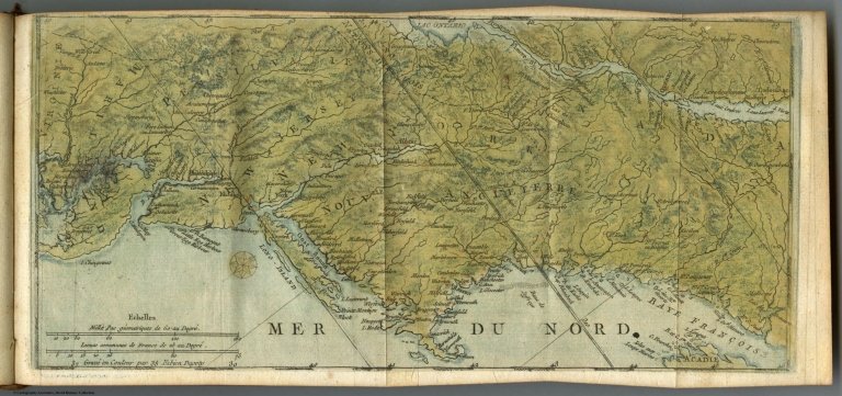
List No
0346.020
Note
In outline color with the future Vermont in yellow. Land grants are shown directly south of the "Coughsaghrage or the Beaver Hunting Country Of The Confederate Indians." Hudson River inset shows soundings and New York City's plan includes numbered buildings and a list of references.
Author
Jefferys, Thomas
Full Title
A New Map Of The Province of Quebec, according to The Royal Proclamation, of the 7th of October 1763. from The French Surveys Connected with those made after the War. By Captain Carver, and Other Officers, in His Majesty's Service. (with) four inset maps: A Particular Survey Of The Isles of Montreal; Plan of Montreal, or Villemarie; The City of Quebec; Course of the River St. Laurence, from la Valterie to Quebec on a Larger Scale. London. Printed for Robt. Sayer and John Bennett ... 16th February 1776.
List No
0346.021
Note
In outline color with the waterways in a blue wash. The cities are shown with labeled points of reference.
Author
Jefferys, Thomas
Full Title
A Map Of Pennsylvania Exhibiting not only The Improved Parts of that Province, but also Its Extensive Frontiers: Laid down From Actual Surveys, and Chiefly From The Late Map of W. Scull Published in 1770; And Humbly Inscribed To The Honourable Thomas Penn And Richard Penn Esquires True And Absolute Proprietaries & Governors Of The Province Of Pennsylvania and the Territories thereunto belonging. London Printed for Robt. Sayer & J. Bennett ... June 1775.
List No
0346.022
Note
In outline color. Map becomes progressively less detailed as it moves west. Swamps, forts, and camps are included as well as a few towns in the westernmost regions.
|