|
|
Author
[Colton, J. H., Smith, J. Calvin]
Full Title
Colton's Township and Railroad Map Of The United States Of America Including a Large Portion of Canada, New Brunswick &c. Showing the Base Meridian and Township Lines of the U.S. Surveys. Rail Roads and other Internal Improvements. Compiled from surveys of the United States Land Office, and various other authentic sources. Published by J.H. Colton, 172 William St. New York. 1862. Entered ... 1843 by Geo. E. Sherman & J. Calvin Smith ... New York. Entered ... 1860 by J.H. Colton ... New York ... (inset) Map Of North America. (inset) Southern Part Of Florida.
List No
10277.000
Note
This is a late edition of the Colton/Smith map of the United States, first issued in 1843. Smith's name is removed and the title is modified to emphasize railroad development. No mention of the Civil War is made on the map even though the map was published during the fighting. There are many updates to the geography, showing new states and territories as well as railroads.
Author
[Burr, David H., 1803-1875, Colton, J. H.]
Full Title
(Covers to) United States. By David H. Burr. Published by J.H. Colton & Co. New York. 9 Wall Street. 1833. Engraved by S. Stiles & Co., N. York. Entered ... 1833, by J.H. Colton & Co. ... New York.
List No
0110A
Note
Dark teal leather covers 13.5x8 with "Burr's Map of the United States Published By J.H. Colton & Co. New York" and a decorative border stamped in gilt.
Author
[Burr, David H., 1803-1875, Colton, J. H.]
Full Title
United States. By David H. Burr. Published by J.H. Colton & Co. New York. 9 Wall Street. 1833. Engraved by S. Stiles & Co., N. York. Entered ... 1833, by J.H. Colton & Co. ... New York.
List No
0110.001
Note
This is the first year of Colton's map publishing business. Ristow says that Colton published his first map in 1833, Burr's map of New York State; this U.S. map must be as early. The graphic style is similar to Burr's Universal Atlas maps, engraved the following year. With six detailed and elegant inset maps showing the environs of Albany, Boston, New York, Cincinnati, Philadelphia, and Baltimore & Washington; plus a small inset map of South Part of Florida. Outline color, folded into dark teal leather covers 13.5x8 with "Burr's Map of the United States Published By J.H. Colton & Co. New York" and a decorative border stamped in gilt. Prime meridians: Greenwich and Washington.
Author
[Colton, G.W., Colton, J. H.]
Full Title
(Covers to) Map Of The Country Thirty Three Miles Around The City Of New York. Published By J.H. Colton, No. 86 Cedar St. New York, 1853. Entered ... 1846, by J.H. Colton ... New York. Drawn by G.W. Colton. Engraved by J.M. Atwood, N.Y.
List No
0173A
Author
[Colton, G.W., Colton, J. H.]
Full Title
Map Of The Country Thirty Three Miles Around The City Of New York. Published By J.H. Colton, No. 86 Cedar St. New York, 1853. Entered ... 1846, by J.H. Colton ... New York. Drawn by G.W. Colton. Engraved by J.M. Atwood, N.Y.
List No
0173.001
Note
With red cloth covers 14.5x9 stamped with gilt title reading "Thirty Three Miles Around The City Of New-York." and a small circular map of New York (later editions omit the map on the cover). First issued in 1846, when it was reengraved by Atwood from J.H. Eddy's "Map of the Country Thirty Miles round the City of New York" which was originally issued in 1811 (see our #3472). This is one of Colton's most attractive maps, showing New York and vicinity in circular format surrounded by a vine border with views of City Hall, New York and City Hall, Brooklyn. It was published in many editions for almost fifty years - our latest edition is 1891 (Haskell lists eight editions from 1846 to 1873 only). The early editions were engraved on copper plate (our 1853) and at some point before our 1865 edition the copper plate was transferred to lithographic stone and all subsequent editions were lithographed.
Author
Colton, J. H.
Full Title
Letter to Mr. G.C. Barclay from J.H. Colton dated February 26th, 1864 from New York.
List No
0185A
Note
Note concerning the use of his maps as advertisements. The letter is on company letterhead.
Author
[Colton, J. H., Norman, B.M., Persac, A.]
Full Title
Norman's Chart Of The Lower Mississippi River By A. Persac. Published by B.M. Norman, New Orleans, La. 1858. Entered ... 1858 by B.M. Norman ... Louisiana. Engraved, Printed & Mounted By J.H. Colton & Co. New York. (At top) From Natchez to New Orleans.
List No
2752.000
Note
Views; shows Plantations by type; very scarce. In full color; lacks original covers. See our reproduction copy issued by Pelican Press, originally in 1931, and printed by Rand McNally - this reproduction greatly alters the original. Ritzlin catalogue: "Persac was a well known surveyor and landscape painter... the map is quite scarce and normally in poor condition because most copies were used by river pilots to locate plantation landings. Few copies are known in contemporary boards. NUC lists only three copies ... however several copies are located in the south, including one which the Louisiana Supreme Court still uses in land ownership cases." Incredible detail, showing the Plantations on both sides of the river. Four engraved views. Engraved by J.H. Colton. Lacking boards, this copy has some tears at the folds with slight loss at some intersections, some light browning in two areas, but is overall a very good copy. Copies at LSU, Historic New Orleans Collection (504-523-4662). See Antiques Magazine, Nov. 1991 for Persac Article. Norman also published "Norman's New Orleans and Environs" with a map of the city, in 1845 (see our copy).
Author
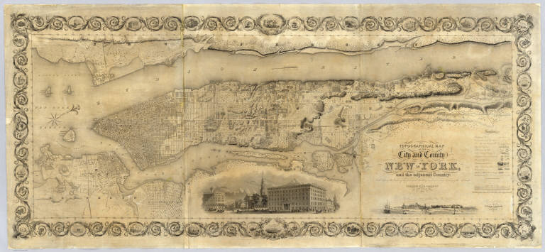
Colton, J. H.
Full Title
Topographical Map Of The City and County Of New - York, and the adjacent Country: With Views in the border of the principal Buildings and interesting Scenery of the Island. Published By J.H. Colton & Co. No. 4 Spruce St. New-York. 1836. Engraved & Printed by S. Stiles & Company, New-York. Entered ... 1836, by J.H. Colton & Co. ... New York.
List No
2784.000
Note
1st ed., 2nd state. Stokes: "This is one of the most beautiful nineteenth century plans or maps of Manhattan Island, and is full of interesting information, It is perhaps the last example of really artistic map-making, as applied to Manhattan Island." Ristow believes that Burr may have drawn this map based on similarities between it and the Burr New York City map that appeared in Burr's New York State Atlas of 1829. Accompanied by the "Summary History.." Stokes describes his copy of the 1st edition as not listing Madison Square and some other differences between the 1836 and 1841 editions which would lead one to conclude that this copy is slightly later than 1836 (it shows Madison Square which was established in 1837) - apparently an unrecorded 2nd state of the first edition. Without color or top and bottom rollers.
Author
Colton, J. H.
Full Title
(Covers to) Maine. 1853. Published By J.H. Colton. No. 86 Cedar St. New York. Entered ... 1853, by J.H. Colton ... New York.
List No
3164A
Note
First edition, from the "Travelling Maps" series, with Census information on verso and unique border. The inside front cover has a label of "The Portland Map Depository... Brown & Hall, Gen'l Ag'ts." Full color, folded into stamped black cloth covers 13x9 with "Map Of Maine J.H. Colton" in gilt.
Author
Colton, J. H.
Full Title
Maine. 1853. Published By J.H. Colton. No. 86 Cedar St. New York. Entered ... 1853, by J.H. Colton ... New York.
List No
3164.001
Note
First edition, from the "Travelling Maps" series, with Census information on verso and unique border. The inside front cover has a label of "The Portland Map Depository... Brown & Hall, Gen'l Ag'ts." Full color, folded into stamped black cloth covers 13x9 with "Map Of Maine J.H. Colton" in gilt.
Author
[Colton, J. H., Creuzbaur, Robert, De Cordova, Jacob]
Full Title
(Covers to) J. De Cordova's Map Of The State Of Texas Compiled from the records of the General Land Office of the State by Robert Creuzbaur, Revised and Corrected by Charles W. Pressler. Published by J.H. Colton & Co. No. 172 William St. New York 1856. Engraved by J.M. Atwood, New York. Entered ... 1856 by J. De Cordova ... Texas. (with untitled inset of southwestern U.S.).
List No
3366A
Author
[Colton, J. H., Creuzbaur, Robert, De Cordova, Jacob]
Full Title
J. De Cordova's Map Of The State Of Texas Compiled from the records of the General Land Office of the State by Robert Creuzbaur, Revised and Corrected by Charles W. Pressler. Published by J.H. Colton & Co. No. 172 William St. New York 1856. Engraved by J.M. Atwood, New York. Entered ... 1856 by J. De Cordova ... Texas. (with untitled inset of southwestern U.S.).
List No
3366.001
Note
First edition of Pressler's revision of De Cordova's map, and first edition published by Colton. Shows Texas east of the 102nd meridian. First issued by De Cordova in 1849, with editions of 1850, 51, 53, 56, 57, 58, and 61 (Ristow and Rosenberg), and a late unlisted edition in 1867 (see our #4801). De Cordova employed Pressler to revise the map in 1855 and then sold the rights to Colton in the same year. The 1849 edition has only two copies located. Eberstadt called the 1849 issue "possibly the finest (Texas map) of the period." Colton changed the inset map from the oval showing all of Texas to the southwestern portion of Colton's U.S. atlas map. J.M. Atwood was the engraver of all editions. With a list of the Land districts, this map was useful for both land promoters and settlers. Colton published a reduced version of the map in his 1856 Atlas of the World. The full color map is folded into stamped dark maroon leather covers 16x10.5 with "J. De Cordova's Texas J.H. Colton & Co. New York." in gilt.
Author
Colton, J. H.
Full Title
(Covers to) Nebraska And Kansas. Published By J.H. Colton & Co. No. 172 William St. New York. Entered ... 1854 by J.H. Colton ... New York. (inset) Map Of The Territory acquired from Mexico by the Gadsden Treaty, 1854. (untitled inset of U.S., Mexico, Central America). Printed by D. Mc Lellan, 26 Spruce St. N.Y.
List No
3873A
Author
Colton, J. H.
Full Title
Nebraska And Kansas. Published By J.H. Colton & Co. No. 172 William St. New York. Entered ... 1854 by J.H. Colton ... New York. (inset) Map Of The Territory acquired from Mexico by the Gadsden Treaty, 1854. (untitled inset of U.S., Mexico, Central America). Printed by D. Mc Lellan, 26 Spruce St. N.Y.
List No
3873.001
Note
First edition, first state. First map to show the new Kansas and Nebraska; also shows the important Gadsden Purchase of the same year. This state precedes all other copies we have seen - it is an early pull from the late 1854, early 1855 Colton Map of the United States of America... wall map plate (see our #2834, indicating it appeared in middle or late 1854 - see our 1855 wall map copy #2278 for the corrected topography), with the title different from the second 1854 state, in that the letters of Nebraska and Kansas have stars in them and are open as opposed to the black letters of the second state. Also, this first state has numerous areas that are "cleaned up" in the second state: the trail that crosses the two forks of the Colorado in southern Utah near the map edge has the word "Route" on it - this is removed in the second state; the vine border is reversed from the first to the second state; Louisiana is written straight across in the first - it curves down in the second; Bucksport and San Augustine are shown in Texas along the map southern edge in the second state and not in the first; Sacket's Well and Laguna in California in the inset map are given dots for their location in the second state but not in the first. There are other changes. Streeter shows a second edition in 1855, Heaston a third edition in 1856, but both copyrighted 1855. These have various route changes and place names added when compared to the 1854. A fourth edition appeared in 1857 (see Karrow 12-0361.2 and Graff 836) with the inset of the U.S. changed to Eastern Nebraska and Kansas. Map is full color by state, folded into red cloth covers 15x9 with "Nebraska And Kansas" stamped in gilt, advertisement for Colton on inside front cover.
Author
[Burr, David H., 1803-1875, Colton, J. H.]
Full Title
(Covers to ) New-York. By David H. Burr. Published by J.H. Colton & Co. 9 Wall Street New-York. 1833. Entered ... 1833 by J.H. Colton & Co. ... New York. Engraved & Printed by S. Stiles & Co. No. 9 Wall St. N. York. (with 5 inset maps)
List No
0109.001
Note
This is the first map printed by J.H. Colton. Originally published by Burr in his large Atlas of New York State, S. Stiles has reengraved and updated this map, still using the same scale, but adding five inset maps. See Burr's small 1838 Atlas of New York State for the 1836 edition of this map (our #108). Full color. Folded into brown leather covers 13.5x9 with "New York" and a decorative border stamped in gilt.
Author
[Burr, David H., 1803-1875, Colton, J. H.]
Full Title
New-York. By David H. Burr. Published by J.H. Colton & Co. 9 Wall Street New-York. 1833. Entered ... 1833 by J.H. Colton & Co. ... New York. Engraved & Printed by S. Stiles & Co. No. 9 Wall St. N. York. (with 5 inset maps)
List No
0109.002
Note
This is the first map printed by J.H. Colton. Originally published by Burr in his large Atlas of New York State, S. Stiles has reengraved and updated this map, still using the same scale, but adding five inset maps. See Burr's small 1838 Atlas of New York State for the 1836 edition of this map (our #108). Full color. Folded into brown leather covers 13.5x9 with "New York" and a decorative border stamped in gilt.
Author
Colton, J. H.
Full Title
(Covers to) Map Of The United States The British Provinces Mexico &c. Showing the Routes of the U.S. Mail Steam Packets to California, & A Plan of the Gold Region. Published By J.H. Colton, 86 Cedar St. New York. 1849. Drawn & Engraved by J.M. Atwood. New York. Entered ... 1849 by J.H. Colton ... New York. (inset) Map Of The Gold Region. California. (untitled inset of South America).
List No
0170A
Author
Colton, J. H.
Full Title
Map Of The United States The British Provinces Mexico &c. Showing the Routes of the U.S. Mail Steam Packets to California, & A Plan of the Gold Region. Published By J.H. Colton, 86 Cedar St. New York. 1849. Drawn & Engraved by J.M. Atwood. New York. Entered ... 1849 by J.H. Colton ... New York. (inset) Map Of The Gold Region. California. (untitled inset of South America).
List No
0170.001
Note
With eleven pages of text titled "Particulars of Routes, Distances, Fares, &c., to Accompany Colton's Map of California and the Gold Region. Collected from Official Documents." On the map there is a view of Pyramid Lake over the title, taken from the Fremont Report and inset maps of the Gold Region and South America, showing the route around Cape Horn. Ackerman did the Lithography for this map as well as the Map of California, Oregon, and Texas (see our #98). This is the second state of the map - the first appeared in Fayette Robinson's "California and its Gold Regions" issued earlier in 1849 (see our 5029). Streeter: "This appears to be the first Colton map showing the gold fields." The North American portion of the map is taken from the North American map inset to the huge Smith/Colton "Map of the United States and the Canadas..." first issued in 1844; this inset later became the Johnson Family Atlas North American map of 1860. The map and the view of Pyramid Lake also appears in a Disturnell/Colton map of North America issued in 1854 and earlier (see our 3507). Outline color. Map is folded into dark blue cloth covers 13.5x8.5 with "Colton's Map Of The United States, Mexico &c. Shewing the Gold Region in California" printed in black on a tan paper label.
Author
Colton, J. H.
Full Title
(Covers to) Colton's New Map Of Indiana. Reduced from his Large Map Exhibiting the Boundaries of Counties, Township Surveys, Location of Cities, Towns, Villages, Post Offices, Canals, Rail Roads & other Internal Improvements. New-York, Published by J.H. Colton. 1853.
List No
0174.001
Note
Colton's first pocket map of Indiana and one of the first maps issued in his "Travelling Maps" series, which were the precursors of the state atlas map sheets in his 1855 Atlas of America (see our #147). With a table of population in the upper right and a unique vine border, not seen on any other Colton pocket maps. There is a border letter locator key indicating that this is the same map that was used in the 1852 Fisher/Colton "Indiana In Relation to Its Geography, Statistics..." Full color by county, folded into patterned brown cloth covers 12.5x8.5 with "Map Of Indiana J.H. Colton" in gilt. Prime meridian is Washington D.C.
Author
Colton, J. H.
Full Title
Colton's New Map Of Indiana. Reduced from his Large Map Exhibiting the Boundaries of Counties, Township Surveys, Location of Cities, Towns, Villages, Post Offices, Canals, Rail Roads & other Internal Improvements. New-York, Published by J.H. Colton. 1853.
List No
0174.002
Note
Colton's first pocket map of Indiana and one of the first maps issued in his "Travelling Maps" series, which were the precursors of the state atlas map sheets in his 1855 Atlas of America (see our #147). With a table of population in the upper right and a unique vine border, not seen on any other Colton pocket maps. There is a border letter locator key indicating that this is the same map that was used in the 1852 Fisher/Colton "Indiana In Relation to Its Geography, Statistics..." Full color by county, folded into patterned brown cloth covers 12.5x8.5 with "Map Of Indiana J.H. Colton" in gilt. Prime meridian is Washington D.C.
Author
Colton, J. H.
Full Title
(Covers to) Illinois. Published By J.H. Colton No. 86 Cedar St. New York. 1854. Entered ... 1853, by J.H. Colton ... New York. (inset) Vicinity of Chicago.
List No
0176.001
Note
Third edition, first edition being 1852. "Traveling Maps" series, with census data on verso. Earlier than the 1855 American Atlas Illinois, with fewer railroads. Folded into red cloth covers 12.5x9 with "Map Of Illinois J.H. Colton" stamped in gilt. Full color. Prime meridians are Greenwich and Washington D.C.
Author
Colton, J. H.
Full Title
Illinois. Published By J.H. Colton No. 86 Cedar St. New York. 1854. Entered ... 1853, by J.H. Colton ... New York. (inset) Vicinity of Chicago.
List No
0176.002
Note
Third edition, first edition being 1852. "Traveling Maps" series, with census data on verso. Earlier than the 1855 American Atlas Illinois, with fewer railroads. Folded into red cloth covers 12.5x9 with "Map Of Illinois J.H. Colton" stamped in gilt. Full color. Prime meridians are Greenwich and Washington D.C.
Author
Colton, J. H.
Full Title
(Covers to) Colton's New Map Of Indiana. Reduced from his Large Map Exhibiting the Boundaries of Counties, Township Surveys, Location of Cities, Towns, Villages, Post Offices, Canals, Rail Roads & other Internal Improvements. New-York, Published by J.H. Colton & Co. 1854. Entered ... 1854, by J.H. Colton ... New York.
List No
0178.001
Note
This is the second edition of this map, issued for Colton's "Travelling Maps" series, with a new vine border that is changed from the first edition, but still with the locator key. Folded into patterned black cloth covers 12.5x8.5 with "Map Of Indiana J.H. Colton" in gilt. Prime meridian is Washington D.C.
Author
Colton, J. H.
Full Title
Colton's New Map Of Indiana. Reduced from his Large Map Exhibiting the Boundaries of Counties, Township Surveys, Location of Cities, Towns, Villages, Post Offices, Canals, Rail Roads & other Internal Improvements. New-York, Published by J.H. Colton & Co. 1854. Entered ... 1854, by J.H. Colton ... New York.
List No
0178.002
Note
This is the second edition of this map, issued for Colton's "Travelling Maps" series, with a new vine border that is changed from the first edition, but still with the locator key. Folded into patterned black cloth covers 12.5x8.5 with "Map Of Indiana J.H. Colton" in gilt. Prime meridian is Washington D.C.
Author
[Colton, J. H., Colton, G. Woolworth]
Full Title
(Covers to) Colton's Township Map Of The State Of Iowa Compiled from the United States Surveys, & other Authentic Sources. Published By J.H. Colton And Co. No. 172 William St. New York. 1855. Entered ... 1851, by J.H. Colton ... New York. Drawn by Geo W. Colton. Engraved by J.M. Atwood.
List No
0180.001
Note
The fifth edition. Omaha City is shown for the first time, with the railroad connection from the east. Full color by county, folded into stamped black cloth covers 14.5x9 with "Township Map Of The State Of Iowa Published By J.H. Colton" in gilt.
Author
[Colton, J. H., Colton, G. Woolworth]
Full Title
Colton's Township Map Of The State Of Iowa Compiled from the United States Surveys, & other Authentic Sources. Published By J.H. Colton And Co. No. 172 William St. New York. 1855. Entered ... 1851, by J.H. Colton ... New York. Drawn by Geo W. Colton. Engraved by J.M. Atwood.
List No
0180.002
Note
The fifth edition. Omaha City is shown for the first time, with the railroad connection from the east. Full color by county, folded into stamped black cloth covers 14.5x9 with "Township Map Of The State Of Iowa Published By J.H. Colton" in gilt.
Author
Colton, J. H.
Full Title
Letter to O.M. Hatch, Secretary of State for State of Illinois from J.H. Colton, dated March 30, 1861 from New York.
List No
0183A
Note
Complains of bribery by Robert Pearsall Smith. Colton claims that he has been unable to get from the State of Illinois the statistical information he needs on Illinois counties and towns and that Smith has offered to sell him the same information that Smith obtained from Washington (by "inducements" according to Colton) for an "exorbitant price." Colton refers to himself as the "oldest and most extensive publisher of Geographical and Statistical works in this country."
Author
Colton, J. H.
Full Title
Stream Of Time, Or Chart Of Universal History, From The Original German Of Strass. Revised By D. Haskel. Published By J.H. Colton, No. 86 Cedar St. New York 1842.
List No
1704.000
Note
Stream of Time maps were popular in the second half of the 19th century (see our 1858 Tableau De L'Histoire Universelle by Pick) and later, but this map or diagram by Colton is an early example, at least in the United States. The period covered starts with the Creation in 4004 BC and extends down to 1842. The bottom of the map has an Explanation which states that "Each Nation is represented by a stream which is broken in upon or flows on undisturbed as it is influenced by the accession of Territory or the remaining at Peace." With hand painted color and black top and bottom rollers.
Author
[Colton, J. H., Colton, G. Woolworth]
Full Title
(Covers to) Colton's Township Map Of The State Of Iowa Compiled from the United States Surveys, & other Authentic Sources. Published By J.H. Colton. No. 172 William St. New York. 1854. Entered ... 1851, by J.H. Colton ... New York. Drawn by Geo W. Colton. Engraved by J.M. Atwood.
List No
1707.001
Note
The fourth edition. The public surveys and railroads are moving relentlessly north and west. Full color by county, folded into stamped brown cloth covers 14.5x9 with "Township Map Of The State Of Iowa Published By J.H. Colton" in gilt. Prime meridians are Greenwich and Washington D.C.
Author
[Colton, J. H., Colton, G. Woolworth]
Full Title
Colton's Township Map Of The State Of Iowa Compiled from the United States Surveys, & other Authentic Sources. Published By J.H. Colton. No. 172 William St. New York. 1854. Entered ... 1851, by J.H. Colton ... New York. Drawn by Geo W. Colton. Engraved by J.M. Atwood.
List No
1707.002
Note
The fourth edition. The public surveys and railroads are moving relentlessly north and west. Full color by county, folded into stamped brown cloth covers 14.5x9 with "Township Map Of The State Of Iowa Published By J.H. Colton" in gilt. Prime meridians are Greenwich and Washington D.C.
Author
Colton, J. H.
Full Title
(Covers to) Pennsylvania. Published By J.H. Colton, No. 86 Cedar St. New York. 1854. Entered ... 1853, by J.H. Colton ... New York.
List No
2136.001
Note
One of the Travelling Maps series that is the source of the 1855 Colton Atlas of America. Census data on rear; same border as the Atlas map. Folded into black cloth covers 12.5x8.5 with "Map Of Pennsylvania J.H. Colton" in gilt. Prime meridians are Greenwich and Washington D.C. Relief shown by hachures.
Author
Colton, J. H.
Full Title
Pennsylvania. Published By J.H. Colton, No. 86 Cedar St. New York. 1854. Entered ... 1853, by J.H. Colton ... New York.
List No
2136.002
Note
One of the Travelling Maps series that is the source of the 1855 Colton Atlas of America. Census data on rear; same border as the Atlas map. Folded into black cloth covers 12.5x8.5 with "Map Of Pennsylvania J.H. Colton" in gilt. Prime meridians are Greenwich and Washington D.C. Relief shown by hachures.
Author
Colton, J. H.
Full Title
Colton's Map of New Jersey. Prepared for the State Insurance Company, Office No.9 Exchange Place, Jersey City. Entered ... 1855 by J.H. Colton & Co. ... New York. C.O. Jones 76 Cedar St. N.Y. (advertisement above map) The State Insurance Company. Stock Company. Charter Perpetual. Office Jersey City, 9 Exchange Place ...
List No
2287.000
Note
Colton sold his maps for uses like this. The map is surrounded by advertisements for the Insurance Company. Full color by county. With black top and bottom rollers.
Author
Colton, J. H.
Full Title
(Covers to) Subscribers to Colton's American Atlas and Atlas of The World. New York: J.H. Colton and Company. London: Trubner and Company. (Leather bound subscription book issued by Colton for his salesmen).
List No
2525A
Author
Colton, J. H.
Full Title
(Title Page to) Subscribers to Colton's American Atlas and Atlas of The World. New York: J.H. Colton and Company. London: Trubner and Company. (Leather bound subscription book issued by Colton for his salesmen).
List No
2525B
Note
J.C. French's subscription book, Cambridge, Mass. Jared Sparks (President of Harvard) is the first subscriber, followed by C.S. Cartee, and other eminent men. This book reveals that the Atlas was published in 27 parts starting in 1854, and was still available in parts in 1855 (see news articles in rear). Prices, bindings, coloring detailed. Apparently the atlas was only available by subscription in 1854, 55, 56, and part of 57. The list ends in 1857, perhaps indicating that the marketing changed, or that Mr. French went on to other pursuits. Book bound in full red leather with "Colton's Atlas" in gilt on cover.
Author
Colton, J. H.
Full Title
Subscribers to Colton's American Atlas and Atlas of The World. New York: J.H. Colton and Company. London: Trubner and Company. (Leather bound subscription book issued by Colton for his salesmen).
List No
2525C
Note
Publishers' Condition describes the way the atlas will look and the costs given the style of binding. The subscription list begins with Jared Sparks, the President of Harvard, who chose to purchase one Atlas of the World.
Author
Colton, J. H.
Full Title
Subscribers to Colton's American Atlas and Atlas of The World. New York: J.H. Colton and Company. London: Trubner and Company. (Leather bound subscription book issued by Colton for his salesmen).
List No
2525D
Note
A full subscription page from the booklet.
Author
Colton, J. H.
Full Title
Subscribers to Colton's American Atlas and Atlas of The World. New York: J.H. Colton and Company. London: Trubner and Company. (Leather bound subscription book issued by Colton for his salesmen).
List No
2525E
Note
Left hand side has lightly written notes by French that includes addresses and names (probably leads). The right hand side has an announcement of the new atlas with French mentioned as the "sole Agent for Charlestown."
Author
Colton, J. H.
Full Title
Subscribers to Colton's American Atlas and Atlas of The World. New York: J.H. Colton and Company. London: Trubner and Company. (Leather bound subscription book issued by Colton for his salesmen).
List No
2525F
Note
Two pages of reviews and announcements about Colton's Atlas from the City Advertiser, November 15, 1854 and the Daily Evening Traveller.
Author
Colton, J. H.
Full Title
Subscribers to Colton's American Atlas and Atlas of The World. New York: J.H. Colton and Company. London: Trubner and Company. (Leather bound subscription book issued by Colton for his salesmen).
List No
2525G
Note
Two pages of reviews and announcements about the Atlas of the World from the City Advertiser, the Bunker Hill Aurora (March 31, 1855) and the Boston Post.
Author
[Colton, J. H., Colton, G. Woolworth]
Full Title
(Covers to) Colton's Township Map of the State of Wisconsin, Complied from the United States Surveys, & other Authentic Sources. Published by J.H. Colton, No. 86 Cedar St. New York. 1852. Drawn by George W. Colton. Engraved by J.M. Atwood, N. York. Entered ... 1851 by J.H. Colton ... N. York.
List No
2796.001
Note
2nd edition, 1st edition was 1851. Colton published his Wisconsin map two years before Chapman's first map (see our #137) and was preceded only by Lapham's maps of the mid 1840's (see our #5208). Map is full color by county and covers the entire state. Folded into stamped brown cloth covers 14.5x9 with "Township Map Of The State Of Wisconsin Published By J.H. Colton" in gilt.
Author
[Colton, J. H., Colton, G. Woolworth]
Full Title
Colton's Township Map of the State of Wisconsin, Complied from the United States Surveys, & other Authentic Sources. Published by J.H. Colton, No. 86 Cedar St. New York. 1852. Drawn by George W. Colton. Engraved by J.M. Atwood, N. York. Entered ... 1851 by J.H. Colton ... N. York.
List No
2796.002
Note
2nd edition, 1st edition was 1851. Colton published his Wisconsin map two years before Chapman's first map (see our #137) and was preceded only by Lapham's maps of the mid 1840's (see our #5208). Map is full color by county and covers the entire state. Folded into stamped brown cloth covers 14.5x9 with "Township Map Of The State Of Wisconsin Published By J.H. Colton" in gilt.
Author
Colton, J. H.
Full Title
(Covers to) Topographical Map Of The West Indies And The Adjacent Coasts By John Pinkerton, Revised, Corrected and Published by J.H. Colton. No. 86 Cedar St. New York, 1853. Drawn under the direction of Mr. Pinkerton by L. Hebert. Neele sculpt. 352, Strand.
List No
2828.001
Note
This is the extraordinary reuse of an actual Pinkerton map plate of 1809 to make a pocket map in 1852. Colton has taken the almost fifty year old Pinkerton copper plate, made some corrections to the topography (see erased lake in Florida) and added modern features such as railroads in Cuba, new settlements, and a list of Geographical Statistics in the upper right. He probably reissued it because the Pinkerton map is beautifully done and most of the basic topography remained correct. Where he got the plate is somewhat of a mystery, although it may have been obtained from successors to the Philadelphia publisher Thomas Dobson who issued the Philadelphia edition of Pinkerton's Modern Atlas in 1818 (see our #4840). Neele and Hebert are still credited below the neat line. Map is folded into stamped brown cloth covers 14.5x9 with "Map Of The West Indies J.H. Colton" in gilt. Full color. Relief shown by hachures. Prime meridian is Greenwich.
Author
Colton, J. H.
Full Title
Topographical Map Of The West Indies And The Adjacent Coasts By John Pinkerton, Revised, Corrected and Published by J.H. Colton. No. 86 Cedar St. New York, 1853. Drawn under the direction of Mr. Pinkerton by L. Hebert. Neele sculpt. 352, Strand.
List No
2828.002
Note
This is the extraordinary reuse of an actual Pinkerton map plate of 1809 to make a pocket map in 1852. Colton has taken the almost fifty year old Pinkerton copper plate, made some corrections to the topography (see erased lake in Florida) and added modern features such as railroads in Cuba, new settlements, and a list of Geographical Statistics in the upper right. He probably reissued it because the Pinkerton map is beautifully done and most of the basic topography remained correct. Where he got the plate is somewhat of a mystery, although it may have been obtained from successors to the Philadelphia publisher Thomas Dobson who issued the Philadelphia edition of Pinkerton's Modern Atlas in 1818 (see our #4840). Neele and Hebert are still credited below the neat line. Map is folded into stamped brown cloth covers 14.5x9 with "Map Of The West Indies J.H. Colton" in gilt. Full color. Relief shown by hachures. Prime meridian is Greenwich.
Author
Colton, J. H.
Full Title
(Covers to) Colton's Map Of The States And Territories West Of The Mississippi River To The Pacific Ocean Showing The Overland Routes, Projected Rail Road Lines &c. Published By J.H. Colton, No. 172 William St. New York. 1864. Entered ... 1864, by J.H. Colton ... New York.
List No
2928A
Author
Colton, J. H.
Full Title
Colton's Map Of The States And Territories West Of The Mississippi River To The Pacific Ocean Showing The Overland Routes, Projected Rail Road Lines &c. Published By J.H. Colton, No. 172 William St. New York. 1864. Entered ... 1864, by J.H. Colton ... New York.
List No
2928.001
Note
First edition. This is the source of Colton's two General Atlas regional maps of the west, beginning with the 1864 atlas edition. This was the first map to show Montana (Wheat). Colton also issued in 1862 (W. Heckrotte copy) "Colton's Map of the Pacific States, California and Oregon...and British Columbia" which is from the same plate, earlier, and goes further north to include much of the Canadian west, but does not go as far east. All these maps derive from "Johnson's New Illustrated & Embellished County Map of the Republics of North America" (see our 1859 edition, #4012) which was first issued in 1856 (We assume this date because our copy says entered in 1856). This shows further that the relationship between Johnson and Colton included Colton using Johnson's maps, as well as Johnson using Colton's maps in Johnson's Family Atlas. Folded into dark green cloth covers 15.5x10 with "Colton's Map Of The States & Territories From The Mississippi River To The Pacific Ocean. &c., &c. J.H. Colton." in gilt. Full color by county.
Author
Colton, J. H.
Full Title
(Covers to) Ohio. Published By J.H. Colton & Co. No. 172 William St. New York. 1855. Entered ... 1855 by J.H. Colton & Co. ... New York. (inset) Vicinity Of Cleveland Cuyahoga Co.
List No
2983.001
Note
From Colton's Travelling Maps series. Possibly the first edition - Karrow lists nothing earlier than the 1856 atlas issue map. Full color by county, folded into patterned black cloth covers 12.5x8.5 with "Map Of Ohio J.H. Colton" in gilt. Prime meridians are Greenwich and Washington D.C.
Author
Colton, J. H.
Full Title
Ohio. Published By J.H. Colton & Co. No. 172 William St. New York. 1855. Entered ... 1855 by J.H. Colton & Co. ... New York. (inset) Vicinity Of Cleveland Cuyahoga Co.
List No
2983.002
Note
From Colton's Travelling Maps series. Possibly the first edition - Karrow lists nothing earlier than the 1856 atlas issue map. Full color by county, folded into patterned black cloth covers 12.5x8.5 with "Map Of Ohio J.H. Colton" in gilt. Prime meridians are Greenwich and Washington D.C.
Author
Colton, J. H.
Full Title
Colton's New Topographical Map Of The Eastern Portion Of The State Of North Carolina With Part Of Virginia & South Carolina From The Latest & Best Authorities. Published by J.H. Colton, No. 172 William St. N.Y. 1863. Entered ... 1860 by J.H. Colton ... New York. Printed by Lang & Cooper, 117 Fulton St. N.Y. (inset) Plan Of The Sea Coast From Virginia To Florida.
List No
3044.000
Note
1st issued 1861. Last issue 1864. With an inset "Plan of the Sea Coast From Virginia to Florida." This map is a companion map to Colton's Topographical Map of the Seat of War in Virginia, Maryland, &c. (see our copy), but on a larger scale (8 miles to an inch vs. 12 miles). It is both highly detailed (railroads, physical features, towns, counties, etc.) and highly decorative (many ships illustrated off the coasts). Map has outline color by state and water painted in blue; inset has full color by state.
Author
Colton, J. H.
Full Title
(Covers to) Maine. 1855. Published By J.H. Colton. No. 172 William St. New York. Entered ... 1853 by J.H. Colton ... New York.
List No
3167.001
Note
The map is the same as the 1855 American Atlas map of the same title except that it is dated 1855 in the title and has no page number (this is typical of the pocket maps derived from the atlas maps). Folded into stamped golden tan cloth covers 13x9 with "Map Of Maine J.H. Colton" in gilt. Prime meridian is Washington D.C.
|