Who What Where WhenREMOVE |
REFINE
Browse All : Images by Vance, David H.
1-10 of 10
Author
[Finley, Anthony, Vance, David H.]
Full Title
(Covers to) Map Of The United States Of North America. Compiled from the Latest And Most Authentic Information By David H. Vance. Philadelphia Published by Anthony Finley. Entered ... July 12th, 1825. Engraved by J.H. Young. (inset) Map Of North America Including All The Recent Geographical Discoveries 1825. (inset profile) Comparative Elevation of the Principal Mountains and Hills in the United States.
List No
3961A
Author
[Finley, Anthony, Vance, David H.]
Full Title
New Map of the United States. Anthony Finley ... Proposes to publish, by subscription, A New and Elegant Map of the United States. Philadelphia, March 27th, 1824.
List No
3961B
Note
Proposal for subscribers. The map was published in 1825 (see our copy, #3961001). This proposal also was published in the back of the 1824 General Atlas, first issue (see our copy, #2680). Pub. Note gives details about the map itself.
Author
[Finley, Anthony, Vance, David H.]
Full Title
Map Of The United States Of North America. Compiled from the Latest And Most Authentic Information By David H. Vance. Philadelphia Published by Anthony Finley. Entered ... July 12th, 1825. Engraved by J.H. Young. (inset) Map Of North America Including All The Recent Geographical Discoveries 1825. (inset profile) Comparative Elevation of the Principal Mountains and Hills in the United States.
List No
3961.001
Note
Full color by county.
Author
Finley, Anthony
Full Title
(Covers to) Map of Kentucky And Tennessee Compiled from the Latest Authorities. Philadelphia Published by A. Finley. D.H. Vance Del. J.H. Young Sculp.
List No
0281.001
Note
Appears to be the same state of the map that is found in Finley's American Atlas of 1826. In brown leather covers 15x9 with "Kentucky & Tennessee" in gilt; no date on map. Full color.
Author
Finley, Anthony
Full Title
Map of Kentucky And Tennessee Compiled from the Latest Authorities. Philadelphia Published by A. Finley. D.H. Vance Del. J.H. Young Sculp.
List No
0281.002
Note
Appears to be the same state of the map that is found in Finley's American Atlas of 1826. In brown leather covers 15x9 with "Kentucky & Tennessee" in gilt; no date on map. Full color. Prime meridian is Washington D.C. Relief shown pictorially.
Author
[Finley, Anthony, Vance, David H.]
Full Title
(Covers to) Map of the State of Missouri And Territory Of Arkansas Compiled From the Latest Authorities. Published by A. Finley Philadelphia. 1826. Drawn by D.H. Vance. Engraved by J.H. Young. (inset) Statistical Table. The State of Missouri Population...1920.
List No
2372.001
Note
Identical to the map of same title that appears in Finley's American Atlas 1826. Full color. Map is folded into brown leather covers 15x9.5 with "Missouri & Arkansas" in gilt. Prime meridian is Washington D.C. Relief shown by hachures.
Author
[Finley, Anthony, Vance, David H.]
Full Title
Map of the State of Missouri And Territory Of Arkansas Compiled From the Latest Authorities. Published by A. Finley Philadelphia. 1826. Drawn by D.H. Vance. Engraved by J.H. Young. (inset) Statistical Table. The State of Missouri Population...1920.
List No
2372.002
Note
Identical to the map of same title that appears in Finley's American Atlas 1826. Full color. Map is folded into brown leather covers 15x9.5 with "Missouri & Arkansas" in gilt. Prime meridian is Washington D.C. Relief shown by hachures.
Author
[Finley, Anthony, Vance, David H.]
Full Title
Map Of The United States Of North America. Compiled from the Latest And Most Authentic Information By David H. Vance. Philadelphia Published by Anthony Finley. Entered according to Act of Congress. Engraved by J.H. Young. 1833. (inset) Map Of North America Including All The Recent Geographical Discoveries. (inset) Comparative Elevation of the Principal Mountains and Hills in the United States. (inset) Topographical View of the Chesapeake and Delaware Canal.
List No
4444.000
Note
This 1833 edition is later than any recorded edition (Karrow shows editions of 1825, 1829, and 1831). There are numerous changes from the 1825 edition: the addition of counties in the developing states, changes to the statistical table to include the census of 1830, new roads, the reduction of Arkansas Territory, and the addition of three canal profiles, two of which replace the steamboat route table and the other placed above the main title. Without rollers. Full color by state or territory.
Author
[Dey, J. Ogden, Vance, David H.]
Full Title
(Covers to) Map of the Western Part of the State Of New York. 1823. By D.H. Vance. Improved and enlarged to the east boundary of the State by J. Ogden Dey 1824. Engraved by Balch, Rawdon & Co. To His Excellency De Witt Clinton ... And ... Stephen Van Rensselaer ... This Map is Inscribed with their permission. By The Publisher John Ogden Dey. Albany January 1825. Copy Right Secured. (with four inset profiles).
List No
4999A
Author
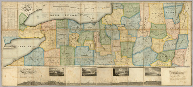
[Dey, J. Ogden, Vance, David H.]
Full Title
Map of the Western Part of the State Of New York. 1823. By D.H. Vance. Improved and enlarged to the east boundary of the State by J. Ogden Dey 1824. Engraved by Balch, Rawdon & Co. To His Excellency De Witt Clinton ... And ... Stephen Van Rensselaer ... This Map is Inscribed with their permission. By The Publisher John Ogden Dey. Albany January 1825. Copy Right Secured. (with four inset profiles).
List No
4999.001
Note
Vance published the upper and western part of this map in 1823 (see Streeter 3818). Dey enlarged it in 1824 and 1825 by adding an eastern portion, taking the state to its eastern boundary with New England, and also adding a lower section that includes a "Geological Profile Extending from the Atlantic to Lake Erie" (which shows the Erie Canal) and four views of the complete Erie Canal. On the main map is a profile of the western and middle sections of the Erie Canal and tables of statistics and geological remarks. The whole production is a celebration of the recently completed Erie Canal. Streeter calls the 1823 issue a "fine large scale colored map." Full color by county. Map has silk edging and is dissected into 36 sections. Folds with marbled paper end sheets, and lies loosely in quarter leather marbled paper covered boards 30x17 with leather ties; "Dey's Improved Map Of N. York" is stamped in gilt on the spine. Scarce.
1-10 of 10
|