
|
|
|
Falls of St. Anthony. Pike, Zebulon Montgomery, 1810
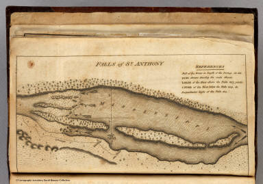 View larger, zoomable image (turn off pop-up blocker) Full Title: Falls of St. Anthony. Author: Pike, Zebulon Montgomery Date: 1810 This historical cartographic image is part of the David Rumsey Historical Map Collection, www.davidrumsey.com, a large collection of online antique, rare, old, and historical maps, atlases, globes, charts, and other cartographic items. Read more about the Collection. Or you can view the entire David Rumsey Map Collection in Insight. Full David Rumsey Map Collection Catalog Record: Author: Pike, Zebulon Montgomery Date: 1810 Short Title: Falls of St. Anthony. Publisher: Phila: C. & A. Conrad Type: Book Map Object Height cm: 11 Object Width cm: 20 Note: The Falls of St. Anthony shown in great detail with a reference list showing the height, width, and length of the falls. Map uncolored. Reference: Wheat 297-9; WC 9:1; cf P11024. Country: Mexico State / Province: U.S. West Full Title: Falls of St. Anthony. List No: 0730.001 Series No: 2 Published In: An Account of Expeditions to the Sources of the Mississippi, and Through the Western Parts of Louisiana, to the Sources of the Arkansaw, Kans, La Platte, and Pierre Jaun, Rivers; ... During the Years 1805, 1806, and 1807. And a Tour Through the Interior Parts of New Spain, When Conducted Through These Provinces, by order of The Captain-General, in the year 1807. By Major Z.M. Pike. Illustrated by Maps and Charts. Philadelphia: Published by C. & A. Conrad & Co. No. 30, Chesnut Street. Somervell & Conrad, Petersburgh. Bonsal, Conrad, & Co. Norfolk, and Fielding Lucas, Jr. Baltimore. John Binns, Printer....1810. Publication Author: Pike, Zebulon Montgomery Publication Date: 1810 Publication Reference: Wheat 297-9; WC 9:1; cf P11024. Publication Note: The five maps which accompany Pike's report are of great importance, especially the two maps of Louisiana which Wheat calls "maps of outstanding historic interest... beautifully drawn." Pike's map of New Spain was copied from Humboldt's manuscript map, although Humboldt did not publish his map until 1811. All maps uncolored and bound into the back of the book. Full leather covers with "Pike's Expeditions" imprinted on the spine. Publication List No: 0730.000 Publication Type: Exploration Book Publication Maps: 6 Publication Height cm: 22 Publication Width cm: 14 Image No: 0730001
Important!
The Insight® Browser and Java client software are products of Luna Imaging, Inc. If you have comments, suggestions, or need help, contact The David Rumsey Collection at home | about | view the
collection | recent
additions | news | help |
