
|
|
|
Mobile, Blakely, Messinger's Ferry-Canton. United States. War Department, 1895
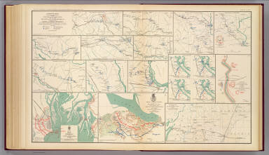 View larger, zoomable image (turn off pop-up blocker) Full Title: No. 10. Map of the defenses of the city of Mobile. Rebel line of works at Blakely, Ala., captured by the Army of West Mississippi, April 9, 1865. Position and approaches by the Union forces. Expedition from Messinger's Ferry toward Canton, Miss., October 14-20, 1863. (with) Campaign maps, numbers 1 to 11 inclusive, showing position of 20th Army Corps on march from Atlanta, Ga. to Savannah, Ga., with dates and Union and rebel defenses, from surveys of Topographical Engineers 20th Army Corps. Position of troops by Lieut. Col. C.W. Asmussen ... December 1864. (with) Position occupied by troops from French's division at the crossing of the Chattahoochee River. S.G. French, Major-General, C.S. Army. Julius Bien & Co., Lith., N.Y. (1891-1895) Author: United States. War Department Date: 1895 This historical cartographic image is part of the David Rumsey Historical Map Collection, www.davidrumsey.com, a large collection of online antique, rare, old, and historical maps, atlases, globes, charts, and other cartographic items. Read more about the Collection. Or you can view the entire David Rumsey Map Collection in Insight. Full David Rumsey Map Collection Catalog Record: Author: United States. War Department Date: 1895 Short Title: Mobile, Blakely, Messinger's Ferry-Canton. Publisher: Washington: U.S. Government Printing Office Type: Atlas Map Object Height cm: 43 Object Width cm: 70 Scale 1: Various Note: Three col. maps, with 15 ancillary maps. Relief shown by hachures. Campaign map 11 contains 4 maps. Accompany reports of Chief of Engineers, U.S. Army, A.S. Williams and James B. McPherson. State / Province: Alabama ; Mississippi ; Georgia County: Warren County (Miss.) ; Hinds County (Miss.) City: Mobile (Ala.) ; Blakeley (Ala.) Event: U.S. Civil War Subject: Military Full Title: No. 10. Map of the defenses of the city of Mobile. Rebel line of works at Blakely, Ala., captured by the Army of West Mississippi, April 9, 1865. Position and approaches by the Union forces. Expedition from Messinger's Ferry toward Canton, Miss., October 14-20, 1863. (with) Campaign maps, numbers 1 to 11 inclusive, showing position of 20th Army Corps on march from Atlanta, Ga. to Savannah, Ga., with dates and Union and rebel defenses, from surveys of Topographical Engineers 20th Army Corps. Position of troops by Lieut. Col. C.W. Asmussen ... December 1864. (with) Position occupied by troops from French's division at the crossing of the Chattahoochee River. S.G. French, Major-General, C.S. Army. Julius Bien & Co., Lith., N.Y. (1891-1895) List No: 1780.071 Page No: pl. LXXI Series No: 75 Engraver or Printer: Julius Bien & Co. ; Asmussen, Charles W. ; French, Samuel G. Published In: Atlas to accompany the official records of the Union and Confederate armies. Published under the direction of the Hons. Redfield Proctor, Stephen B. Elkins and Daniel S. Lamont, secretaries of war, by Maj. George B. Davis, U.S. Army, Mr. Leslie J. Perry, civilian expert, Mr. Joseph W. Kirkley, civilian expert, Board of Publication. Compiled by Capt. Calvin D. Cowles, 23d U.S. Infantry. Washington: Government Printing Office, 1891-1895. Publication Author: United States. War Department; Davis, George B.; Perry, Leslie J.; Kirkley, JAW.; Cowles, Calvin D. Publication Date: 1895 Publication Reference: LC Civil War maps (2nd ed.), 99; Civil War maps in the National Archives, 8; Phillips, 1353; LeGear. Atlases of the United States, 266. Publication Note: See note field above. Publication List No: 1780.000 Publication Type: Military Atlas Publication Maps: 158 Publication Height cm: 47 Publication Width cm: 40 Image No: 1780071
Important!
The Insight® Browser and Java client software are products of Luna Imaging, Inc. If you have comments, suggestions, or need help, contact The David Rumsey Collection at home | about | view the
collection | recent
additions | news | help |
