
|
|
|
Germany (south) (Delarochette, Louis Stanislas d'Arcy); Kitchin, Thomas; (Robert Laurie & James Whittle), 1794
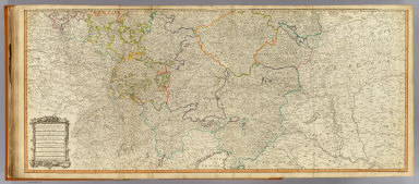 View larger, zoomable image (turn off pop-up blocker) Full Title: (Map of the Empire of Germany, including all the states comprehended under that name: with the Kingdom of Prussia, &c. South half. By L. Delarochette. London, Published by Laurie & Whittle, No. 53, Fleet Street, 12th May, 1794) Author: (Delarochette, Louis Stanislas d'Arcy); Kitchin, Thomas; (Robert Laurie & James Whittle) Date: 1794 This historical cartographic image is part of the David Rumsey Historical Map Collection, www.davidrumsey.com, a large collection of online antique, rare, old, and historical maps, atlases, globes, charts, and other cartographic items. Read more about the Collection. Or you can view the entire David Rumsey Map Collection in Insight. Full David Rumsey Map Collection Catalog Record: Author: (Delarochette, Louis Stanislas d'Arcy); Kitchin, Thomas; (Robert Laurie & James Whittle) Date: 1794 Short Title: Germany (south) Publisher: London: Laurie & Whittle Type: Atlas Map Object Height cm: 52 Object Width cm: 120 Scale 1: 1,250,000 Note: Hand colored engraved map. Relief shown pictorially. Printed on 2 sheets; joined. Contents: The circles of Lower Rhine, Franconia, Swabia and Bavaria, with the southern parts of the circles of Upper Rhine and Saxony, the western parts of Bohemia and of the circle of Austria, Switzerland and part of Italy, France and the Netherlands -- Eastern parts of Bohemia and of the Circle of Austria, with Moravia, and the southern parts of Silesia; part of Poland, Hungary, Sclavonia, Croatia, and Istria. World Area: Europe Country: Germany ; Austria Full Title: (Map of the Empire of Germany, including all the states comprehended under that name: with the Kingdom of Prussia, &c. South half. By L. Delarochette. London, Published by Laurie & Whittle, No. 53, Fleet Street, 12th May, 1794) List No: 2310.039 Page No: (33) Series No: 41 Published In: (A new universal atlas, exhibiting all the empires, kingdoms, states, republics, &c. &c. in the whole World; being a complete collection of the most approved maps extant; corrected with the greatest care, and augmented from the last edition of D'Anville and Robert (de Vaugondy) with many improvements by Major James Rennel, and other eminent geographers, including all the tracks and new discoveries of the British circumnavigators, Biron, Wallis, Carteret, Captain James Cook, Vancouver, Perouse, &c. &c. 6th Ed. ... London, R. Laurie & J. Whittle, 1802) Publication Author: Kitchin, Thomas; Robert Laurie & James Whittle Publication Date: 1802 Publication Reference: P699. Cf Shirley R. Maps in the atlases of the British Library, T.LAU-1c (1799 ed.); NMM 375 (3rd ed. 1801) Publication Note: See note field above. Publication List No: 2310.000 Publication Type: World Atlas Publication Maps: 76 Publication Height cm: 57 Publication Width cm: 41 Image No: 2310039
Important!
The Insight® Browser and Java client software are products of Luna Imaging, Inc. If you have comments, suggestions, or need help, contact The David Rumsey Collection at home | about | view the
collection | recent
additions | news | help |
