
|
|
|
Map of the United States. U.S. War Department, Topographical Engineers, 1850
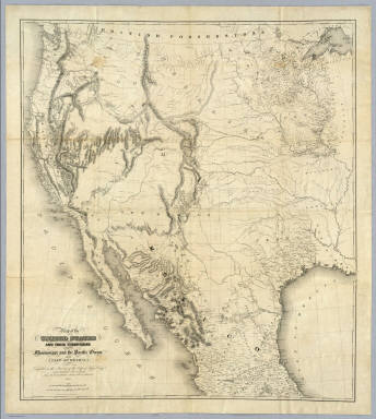 View larger, zoomable image (turn off pop-up blocker) Full Title: Map Of The United States And Their Territories Between The Mississippi and the Pacific Ocean And Of Part of Mexico. Compiled in the Bureau of the Corps of Topogl. Engs. under a Resolution of the U.S. Senate. From the best authorities which could be obtained. 1850. Engraved by Sherman and Smith, New-York. Author: U.S. War Department, Topographical Engineers Date: 1850 This historical cartographic image is part of the David Rumsey Historical Map Collection, www.davidrumsey.com, a large collection of online antique, rare, old, and historical maps, atlases, globes, charts, and other cartographic items. Read more about the Collection. Or you can view the entire David Rumsey Map Collection in Insight. Full David Rumsey Map Collection Catalog Record: Author: U.S. War Department, Topographical Engineers Date: 1850 Short Title: Map of the United States. Publisher: New York: Sherman and Smith Type: Separate Map Object Height cm: 106 Object Width cm: 98 Scale 1: 1:3,168,000 Note: This was the best general map of the American West published by the Topographical Engineers until the Emory and Warren maps of 1857. Wheat calls it "beautiful... a synthesis of the many and varied cartographic activities of the U.S. Army carried on in the West since the onset of the Mexican War, with numerous individual maps subjected to correction and enhanced by new data." A large and imposing production, the map shows the new political divisions of California, Utah and New Mexico and is engraved in the best style by the well known Sherman and Smith firm of New York. Map is without color. Reference: Wheat 696; P-Maps 900; Graff 4302; Streeter 3880. Country: United States ; Mexico State / Province: U.S. West Subject: U.S. War Dept. Full Title: Map Of The United States And Their Territories Between The Mississippi and the Pacific Ocean And Of Part of Mexico. Compiled in the Bureau of the Corps of Topogl. Engs. under a Resolution of the U.S. Senate. From the best authorities which could be obtained. 1850. Engraved by Sherman and Smith, New-York. List No: 5142.000 Series No: 1 Published In: Map Of The United States And Their Territories Between The Mississippi and the Pacific Ocean And Of Part of Mexico. Compiled in the Bureau of the Corps of Topogl. Engs. under a Resolution of the U.S. Senate. From the best authorities which could be obtained. 1850. Engraved by Sherman and Smith, New-York. Publication Author: U.S. War Department, Topographical Engineers Publication Date: 1850 Publication Reference: Wheat 696; P-Maps 900; Graff 4302; Streeter 3880. Publication Note: See note field above. Publication List No: 5142.000 Publication Type: Separate Map Publication Maps: 1 Publication Height cm: 106 Publication Width cm: 98 Image No: 5142000
Important!
The Insight® Browser and Java client software are products of Luna Imaging, Inc. If you have comments, suggestions, or need help, contact The David Rumsey Collection at home | about | view the
collection | recent
additions | news | help |
