
|
|
|
Turkey in Asia. Pinkerton, John, 1758-1826, 1813
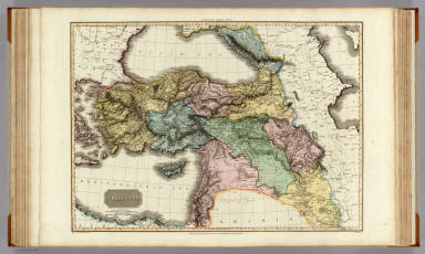 View larger, zoomable image (turn off pop-up blocker) Full Title: Turkey in Asia. Drawn under the direction of Mr. Pinkerton by L. Hebert. Neele sculpt. 352 Strand. London: published Sepr. 1st. 1813, by Cadell & Davies, Strand & Longman, Hurst, Rees, Orme, & Brown, Paternoster Row. Author: Pinkerton, John, 1758-1826 Date: 1813 This historical cartographic image is part of the David Rumsey Historical Map Collection, www.davidrumsey.com, a large collection of online antique, rare, old, and historical maps, atlases, globes, charts, and other cartographic items. Read more about the Collection. Or you can view the entire David Rumsey Map Collection in Insight. Full David Rumsey Map Collection Catalog Record: Author: Pinkerton, John, 1758-1826 Date: 1813 Short Title: Turkey in Asia. Publisher: London: Cadell and Davies; London: Longman, Hurst, Rees, Orme, and Brown Type: Atlas Map Object Height cm: 52 Object Width cm: 70 Scale 1: 3,300,000 Note: Engraved map. Full hand col. Relief shown by hachures. "Pinkerton's modern atlas." Reference: P724; NMC 409. World Area: Asia Country: Turkey ; Syria Full Title: Turkey in Asia. Drawn under the direction of Mr. Pinkerton by L. Hebert. Neele sculpt. 352 Strand. London: published Sepr. 1st. 1813, by Cadell & Davies, Strand & Longman, Hurst, Rees, Orme, & Brown, Paternoster Row. List No: 0732.033 Page No: 31 Series No: 36 Engraver or Printer: Neele, Samuel John, 1758-1824 ; Hebert, L. Published In: A modern atlas, from the latest and best authorities, exhibiting the various divisions of the world, with its chief empires, kingdoms and states, in sixty maps, carefully reduced from the largest and most authentic sources. Directed and superintended by John Pinkerton, author of Modern geography, &c. London: Printed by T. Bensley, Bolt Court, Fleet Street; for T. Cadell and W. Davies, Strand; and Longman, Hurst, Rees, Orme, And Brown, Paternoster Row. 1815. Publication Author: Pinkerton, John, 1758-1826 Publication Date: 1815 Publication Reference: P724; NMC 409. Publication Note: A superb copy. One of the best English Atlases of the period, similar to Thomson's General Atlas of 1817. See the Philadelphia edition of 1818. Maps are hand painted in full color and bound in new half leather beige cloth covered boards with "Pinkerton Atlas" stamped in gilt on a black spine label. Publication List No: 0732.000 Publication Type: World Atlas Publication Maps: 61 Publication Height cm: 59 Publication Width cm: 48 Image No: 0732033
Important!
The Insight® Browser and Java client software are products of Luna Imaging, Inc. If you have comments, suggestions, or need help, contact The David Rumsey Collection at home | about | view the
collection | recent
additions | news | help |
