
|
|
|
Historical map of the State of Ohio. Whittlesey, Chas.; Slater, J. 1872
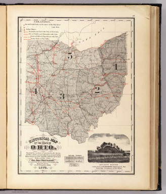 View larger, zoomable image (turn off pop-up blocker) Full Title: Historical map of the State of Ohio. Showing the location of ancient earth works and the country occupied by the principal Indian tribes between 1750 and 1780 with their principal trails and war-paths by Col. Chas. Whittlesey, President of the Western Reserve and Northern Ohio Historical Society, Cleveland, Ohio, 1872. (with view) Ancient mound 2 miles east of Miamisburg, Montgomery Co., Ohio ... Photographed ... by J. Slater, 1872. (Published by Stedman, Brown & Lyon, Cincinnati. 1872. Entered ... 1872, by H.F. Walling, and O.W. Gray, and H.H. Lloyd & Co. ... Washington) Author: Whittlesey, Chas.; Slater, J. Date: 1872 This historical cartographic image is part of the David Rumsey Historical Map Collection, www.davidrumsey.com, a large collection of online antique, rare, old, and historical maps, atlases, globes, charts, and other cartographic items. Read more about the Collection. Or you can view the entire David Rumsey Map Collection in Insight. Full David Rumsey Map Collection Catalog Record: Author: Whittlesey, Chas.; Slater, J. Date: 1872 Short Title: Historical map of the State of Ohio. Publisher: Cincinnati: Stedman, Brown & Lyon. Type: Atlas Map ; View Object Height cm: 38 Object Width cm: 28 Scale 1: 1,500,000 Note: Col. lithographed map. Reference: Checklist of printed maps of the Middle West to 1900, 2-1979; Phillips, 2347; Phillips Maps of America, p. 632; LeGear Atlases of the United States, L2740. State / Province: Ohio County: Montgomery County (Ohio) Subject: Indians Full Title: Historical map of the State of Ohio. Showing the location of ancient earth works and the country occupied by the principal Indian tribes between 1750 and 1780 with their principal trails and war-paths by Col. Chas. Whittlesey, President of the Western Reserve and Northern Ohio Historical Society, Cleveland, Ohio, 1872. (with view) Ancient mound 2 miles east of Miamisburg, Montgomery Co., Ohio ... Photographed ... by J. Slater, 1872. (Published by Stedman, Brown & Lyon, Cincinnati. 1872. Entered ... 1872, by H.F. Walling, and O.W. Gray, and H.H. Lloyd & Co. ... Washington) List No: 2710.001 Page No: 17 Series No: 5 Published In: New topographical atlas of the State of Ohio. With descriptions historical, scientific, and statistical, together with maps of the Untied States and territories. By H.F. Walling, and O.W. Gray, civil and topographical engineers. Published by Stedman, Brown & Lyon, Cincinnati. 1872. Entered ... 1872, by H.F. Walling, and O.W. Gray, and H.H. Lloyd & Co. ... Washington. Publication Author: Walling, H. F.; Gray, Ormando Willis; Lloyd, H. H. Publication Date: 1872 Publication Reference: Checklist of printed maps of the Middle West to 1900, 2-1979; Phillips, 2347; Phillips Maps of America, p. 632; LeGear Atlases of the United States, L2740. Publication Note: H.H. Lloyd's Atlas of U.S. in rear. See the earlier version of this atlas published in 1868 (our #4726). Bound in half leather dark greenish brown cloth covered boards with "Topographical atlas of Ohio and the United States" gold stamped on the front cover and blind stamped on the back. Publication List No: 2710.000 Publication Type: State Atlas Publication Maps: 35 Publication Height cm: 45 Publication Width cm: 36 Image No: 2710001
Important!
The Insight® Browser and Java client software are products of Luna Imaging, Inc. If you have comments, suggestions, or need help, contact The David Rumsey Collection at home | about | view the
collection | recent
additions | news | help |
