
|
|
|
California, Oregon, Washington, Utah, New Mexico. (Mitchell, Samuel Augustus), 1859
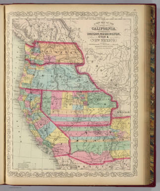 View larger, zoomable image (turn off pop-up blocker) Full Title: A new map of the state of California, the territories of Oregon, Washington, Utah and New Mexico. Published by Charles Desilver, no. 714 Chestnut Street, Philadelphia. Entered according to Act of Congress in the year 1856 by Charles Desilver in the ... District Court of the eastern district of Pennsylvania. (1859) Author: (Mitchell, Samuel Augustus) Date: 1859 This historical cartographic image is part of the David Rumsey Historical Map Collection, www.davidrumsey.com, a large collection of online antique, rare, old, and historical maps, atlases, globes, charts, and other cartographic items. Read more about the Collection. Or you can view the entire David Rumsey Map Collection in Insight. Full David Rumsey Map Collection Catalog Record: Author: (Mitchell, Samuel Augustus) Date: 1859 Short Title: California, Oregon, Washington, Utah, New Mexico. Publisher: Baltimore: Cushings & Bailey Type: Atlas Map Object Height cm: 42 Object Width cm: 33 Scale 1: 6,600,000 Note: Relief shown by hachures and spot heights. Unlike 1858 eds., this does not have "Proposed Arizonia Territory" in Gadsden Purchase. Shows Indian tribes. Prime meridians: Greenwich and Washington. State / Province: U.S. West ; California ; Oregon Full Title: A new map of the state of California, the territories of Oregon, Washington, Utah and New Mexico. Published by Charles Desilver, no. 714 Chestnut Street, Philadelphia. Entered according to Act of Congress in the year 1856 by Charles Desilver in the ... District Court of the eastern district of Pennsylvania. (1859) List No: 4557.001 Page No: 37 Published In: A new universal atlas containing maps of the various empires, kingdoms, states and republics of the World. With a special map of each of the United States, plans of cities &c. Comprehended in eighty one sheets and forming a series of one hundred and forty five maps, plans and sections ... Baltimore, Cushings & Bailey, 262 Market Street. 1858. Entered ... 1856, by Charles Desilver ... Pennsylvania. (title page by) Barralet del. Humphreys, sc. J. Knight Sc. Publication Author: Mitchell, Samuel Augustus Publication Date: 1859 Publication Reference: Phillips, 6135 Publication Note: The scarce last edition listed in Phillips of Mitchell's New Universal Atlas (although we have seen a copy of a title page of the same atlas dated 1862, published by Charles Desilver). The maps still bear the copyright and imprint of Charles Desilver, but his address on most of the maps is changed from 251 Market Street to 714 Chestnut Street. Several of the maps have changes from the 1858 edition: New Jersey has new railroads, Washington D.C. has the column of References redone, North Carolina and South Carolina have been completely redrawn by J.L. Hazard, Mississippi had new railroads, Minnesota is a throwback to the 1857 edition with "Minnesota Territory" as the title, and there are subtle changes in many other maps indicating that even at this late date there was an attempt to keep the atlas current. This edition marks the end of the New Universal Atlas run, which started twenty three years earlier with the Tanner first edition of 1836. Bound in half leather red cloth covered boards with "Mitchell's Universal Atlas" and an elaborate border stamped in gold on the front and "Universal Atlas. Mitchell." on spine. Maps in full color. Publication List No: 4557.000 Publication Type: World Atlas Publication Maps: 76 Publication Height cm: 45 Publication Width cm: 37 Image No: 4557001
Important!
The Insight® Browser and Java client software are products of Luna Imaging, Inc. If you have comments, suggestions, or need help, contact The David Rumsey Collection at home | about | view the
collection | recent
additions | news | help |
