
|
|
|
Map of Washington D.C., 1861
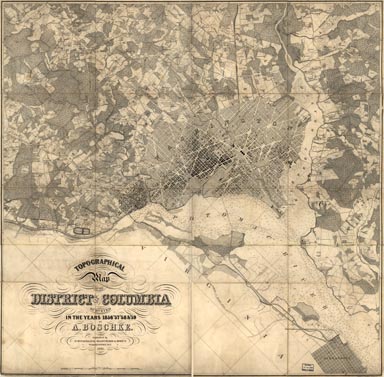 Full Title: Topographical map of the District of Columbia / surveyed in the years 1856 '57 '58 & '59 by A. Boschke ; engraved by D. McClelland, Washington, D.C. Author: Boschke, A. Date: 1861 Partial cadastral map showing some householders' names, individual buildings, and vegetation. Relief shown by contours and hachures. Depths shown by contours and soundings. The original map and this image are from the Library of Congress, Geography and Map Division. The georectifed map image was created by the David Rumsey Map Collection.This historical cartographic image is part of the David Rumsey Historical Map Collection, www.davidrumsey.com, a large collection of online historical maps, atlases and other cartographic items. Read more about the Collection. Or you can view the entire David Rumsey Map Collection in Insight.
Full David Rumsey Map Collection Catalog Record: Author: Boschke, A. Date: 1861 Short Title: Washington, D.C. Publisher: Washington : D. McClelland, Blanchard & Mohun. Type: map Obj Height cm: 99 Obj Width cm: 103 Scale: 1:15,840 Note: Repository: Library of Congress Geography and Map Division (G3850 1861 .B6 Vault Oversize ). Reference: LC Civil War maps (2nd ed.) 678.5 World Area: Washington, D.C. Full Title: Topographical map of the District of Columbia / surveyed in the years 1856 '57 '58 & '59 by A. Boschke ; engraved by D. McClelland, Washington, D.C. Library of Congress Catalog number: G3850 1861 .B6 Vault Oversize
Important!
The Insight® Browser and Java Client software are products of Luna Imaging, Inc. If you have comments, suggestions, or need help, contact The David Rumsey Collection at home | about | view the
collection | recent
additions | news | help |
