 |
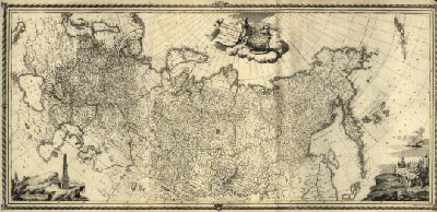
Map of Imperial Russia, 1776
 Full Title: Tabula geographica generalis Imperii Russici ad normam novissimarum observationum astronomicarum concinnata / a Joh. Trescotio et Jac. Schmidio ; vyriezyvali K. Frolov, E. Khudiakov, N. Zubkov. Author: Treskot, Johann, 1719-1786. Date: 1776 This map shows the Russian Empire stretching from Europe east to the Aleutian Islands off North America. The original map and this image are from the Library of Congress, Geography and Map Division. The georectifed map images were created by the David Rumsey Map Collection.This historical cartographic image is part of the David Rumsey Historical Map Collection, www.davidrumsey.com, a large collection of online historical maps, atlases and other cartographic items. Read more about the Collection. Or you can view the entire David Rumsey Map Collection in Insight.
Full David Rumsey Map Collection Catalog Record: Author: Treskot, Johann, 1719-1786. Date: 1776 Short Title: Russian Empire Publisher: St.Petersburg, publisher unknown Type: map Obj Height cm: 64 Obj Width cm: 141 Scale 1: 7,250,000 Note: Relief shown pictorially. Also shows parts of the Aleutian Islands and Eastern Europe. Repository: Library of Congress Geography and Map Division (G7000 1776 .T7). Reference: Related name, Schmidt, Jacob (Jacob F.) World Area: Russia Full Title: Tabula geographica generalis Imperii Russici ad normam novissimarum observationum astronomicarum concinnata / a Joh. Trescotio et Jac. Schmidio ; vyriezyvali K. Frolov, E. Khudiakov, N. Zubkov. Library of Congress Catalog number: G7000 1776 .T7
Important!
The Insight® Browser and Java Client software are products of Luna Imaging, Inc. If you have comments, suggestions, or need help, contact The David Rumsey Collection at home | about | view the
collection | recent
additions | news | help |