 |
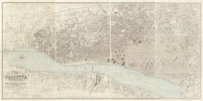
Map of Calcutta, 1858
 Full Title: Map of Calcutta from actual survey in the years 1847-1849 / by Frederick Walter Simms ; the suburbs of the town are from surveys subsequently furnished by Major H.L. Thuillier ; executed by himself & Captain R. Smyth ; reduced and engraved by J. and C. Walker. Author: Simms, Frederick Walter, 1803-1865. Date: 1858 Published by John Walker, Geographer to the Honble. East India Co., Jany. 20th, 1858. The original map and this image are from the Library of Congress, Geography and Map Division. The georectifed map images were created by the David Rumsey Map Collection.This historical cartographic image is part of the David Rumsey Historical Map Collection, www.davidrumsey.com, a large collection of online historical maps, atlases and other cartographic items. Read more about the Collection. Or you can view the entire David Rumsey Map Collection in Insight.
Full David Rumsey Map Collection Catalog Record: Author: Simms, Frederick Walter, 1803-1865. Date: 1858 Short Title: Calcutta Publisher: London, John Walker Type: map Obj Height cm: 111 Obj Width cm: 229 Scale 1: 4,150 Note: Repository: Library of Congress Geography and Map Division (G7654.C2 1857 .S5 Oversize ). Reference: none City: Calcutta Full Title: Map of Calcutta from actual survey in the years 1847-1849 / by Frederick Walter Simms ; the suburbs of the town are from surveys subsequently furnished by Major H.L. Thuillier ; executed by himself & Captain R. Smyth ; reduced and engraved by J. and C. Walker. Library of Congress Catalog number: G7064.M7 1739 .M5 Vault
Important!
The Insight® Browser and Java Client software are products of Luna Imaging, Inc. If you have comments, suggestions, or need help, contact The David Rumsey Collection at home | about | view the
collection | recent
additions | news | help |