 |
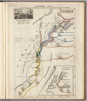
A Series of Maps to Willard's History of the United States, 1829
Willard, Emma, New York
Emma Willard's maps in this school atlas are some of the earliest published maps depicting historical events in the formation of the United States. The maps are thematic and very well drawn. Emma Willard was an important teacher and school leader in the first half of the 19th century in the U.S. She believed that girls and young women should study geography and maps and this atlas is part of her many published school texts that further those goals. View Atlas
|
 |
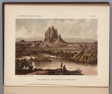
Report Upon The Colorado River of the West, Explored in 1857 and 1858, 1861
Ives, J.C., v. Ecloffstein, F.W., Washington, D.C.
Originally we put online only the maps from this report, now we have added all the plates and images by Mullhausen, Egloffstein and others. This is the scarce Senate issue with four maps by "Baron" Egloffstein. Egloffstein used a unique engraving process to achieve a superb rendering of topographical features; he used the same technique in the map he drew for Macomb's Report. Of the maps in Ives's Report Wheat said "The two maps were drawn by F.W. Egloffstein...the first...is one of his best." Rare in this form with the two additional geological maps in color wash. These only appear in the Senate issue. They are the same as the two "normal" maps that appear in the House and Senate issue, but they have colors overlaid to show geological formations. View Report
|
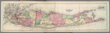 |
Atlas Of Long Island, New York, 1873
Beers, F.W., New York
One of the rarer Beers New York area atlases. View Atlas
|
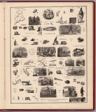 |
A Hieroglyphic Geography Of The United States. Part 1 Containing The States Of Maine, New Hampshire, Vermont, Massachusetts, Rhode Island, Connecticut And New York, 1875
Heermans, Anna A.; Cogswell, Charlotte B., New York
This atlas contains very small state maps filled with "Hieroglyphic" illustrations and views for each state, followed by a page of text. The text pages decode the "Hieroglyphic" images and text on the maps. Unusual use of maps, text, and image to teach geographical information. Apparently there are additional parts (not present here) that cover other states in the U.S. View Atlas
|
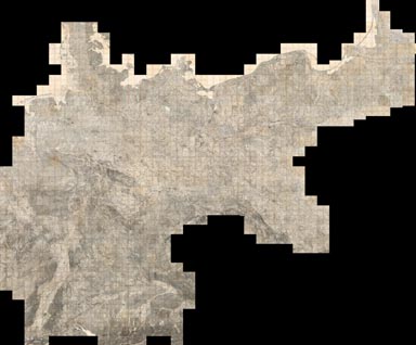 |
Composite Image and Sheets 502 to 674, Karte des Deutschen Reiches, 1893 (various dates, 1880 to 1910)
Reichsamt fur Landesaufnahme, Germany
Our project of scanning and putting online the 674 sheets of the Karte des Deutschen Reich, 1893, is completed - this addition adds the last 346 map images and increases the size of the large composite image to all 674 maps (the image is 390 GB, 401,000 x 332,000 pixels, downloadable as georeferenced 3.6GB JP2). View Composite Map
|
 |
Report of the Exploring Expedition From Santa Fe, New Mexico, To The Junction of the Grand and Green Rivers of the Great Colorado of the West, In 1859, Published in 1876
Macomb, J.N.; Newberry, J.S.;Egloffstein, F.W. von, Washington D.C.
We have added the illustrations and plates by J.N. Newberry to the Egloffstein map, which Wheat calls "one of the most beautiful maps ever published by the Army." Egloffstein made his map in 1864. The publication of the map and the report were delayed by the Civil War. View Report
|
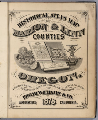 |
Historical Atlas Map Of Marion & Linn Counties Oregon, 1878
Williams, Edgar., San Francisco
This is the only county atlas made of an Oregon county in the 19th century. Its maps and views are very similar in style to those in the Thompson and West California county atlases. The Edgar Williams Company published no other atlases. View Atlas
|
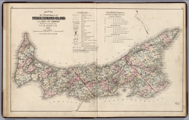 |
Illustrated Historical Atlas Of The Province Of Prince Edward Island, 1880
Meacham, J.H. & Co.; Allen, C.R., Philadelphia
With views, portraits, a list of patrons of the atlas, and land ownership maps. Provincial atlases of the Canadian Maritime Provinces are scarce. View Atlas
|
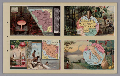 |
Arbuckles' Illustrated Atlas of Fifty Principal Nations of The World. 1890
Arbuckle Bros., New York
Exquisite illustrations and brilliant color. The maps were also issued as individual cards with the coffee products. Maps surrounded by representative scenes from each country. Paper covers and bound with string on the left-hand side. Arbuckle Bros. also issued an Illustrated Atlas of the United States in 1889 View Atlas
|
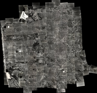 |
Composite Image and Sheets 1 to 164, San Francisco Aerial Views, 1938
Ryker, Harrison, Oakland
We have completed the Composite Image and put online a set of 164 spectacular, large format, sharp, black and white vertical aerial photographs partially overlapping images covering San Francisco in 1938. Resolution generally better than one foot and much higher with high contrast features. Handwritten date on index map indicates photographs taken in August, 1938. Owned by the San Francisco Public Library. View Composite Image in Luna Browser. View Composite Image and Views 1-164 in Luna Browser. View Composite Image or Index in Google Earth Browser. View Composite Image or Index in Google Earth Application.
|
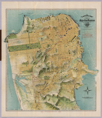 |
The "Chevalier" Commercial, Pictorial and Tourist Map of San Francisco From Latest U.S. Gov. and Official Surveys, 1915
Chevalier, August, San Francisco
A map of San Francisco showing important buildings which are drawn in vignettes on the map. Also showing public improvement described in the Legend as Car Lines. Proposed Tunnels ... Railroads. At the bottom of the map is the publisher's statement "The Exposition City 1915" Full color map bound in brown card board covers with title " 'Chevalier' Illustrated Map & Guide Of San Francisco ( The Exposition City)." With Stamp "Panama-Pacific -International. Exposition. San Francisco California 1915," with the exposition building delineated just west of Fort Mason. Title hows Chevalier's Trade Mark vignette. This is a reduced size version of the wall map published in 1911 and 1915 and is also a reduced version of the pocket map edition of 1904. View Map
|
|
|
World Geo-graphic Atlas, A Composite of Man's Environment. Geography, Geology, Demography, Astronomy, Climatology, Economics, 1953
Bayer, Herbert; Container Corporation of America, Chicago
Lavishly illustrated with drawings and graphics. Editor and designer Herbert Bayer (1900-1985) was prominent in the Bauhaus movement and personally did considerable map research for the atlas. This clear and concise volume relies upon an attractive juxtaposition of physical and political maps, text, thematic maps, illustrations, cross-sections, graphs, and diagrams. Many of the graphics are truly original yet demonstrative of important concepts.From the Preface: "This book is called "WORLD GEO-GRAPHIC ATLAS" because it includes, in addition to GEO-graphic maps, many GRAPHIC illustrations of subjects closely related to modern geography." The atlas demonstrated the post-World War II geopolitical and economic situation. The international maps of this English language atlas are from the Instituto Geografico di Agostini. Maps of the U.S. are by Rand McNally and Company. Relief shown as combined hachures, shaded relief, and hypsometric tints; bathymetry also tinted. Many insets of the vicinities of urban areas. View Atlas
|