 |
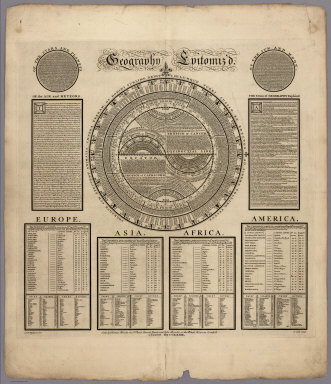
Geography Epitomiz'd. Of The Stars And Planets. Of The Sun And Moon. Of the Air and Meteors. The Terms of Geography Explain'd., 1733
Bowles, Thomas; Bowles, John, London
A remarkable series of cartouches and tables present the summary of geographic and cosmological information. Includes text and list of continents, countries, capital cities, and their coordinates. A very early example of information visualization. View Map
|
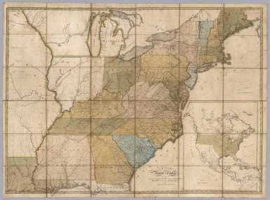 |
Map of the United States, Exhibiting the Post-Roads, the situations, connexions and distances of the Post-Offices, Stage Roads, Counties & Principal Rivers, 1805
Bradley, Abraham Junior, Washington, D.C.
Abraham Bradley published the best maps showing in detail the roads used to move the U.S. mail in the late 18th and early 19th century. This copy is the 2nd edition or state of this map, with printed date of 1804 but with estimated date of 1805 based on the naming of Michigan Territory which was formed in 1805. View Map
|
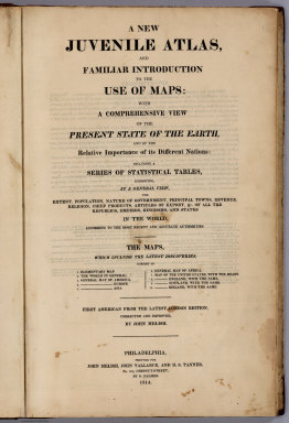 |
A New Juvenile Atlas, And Familiar Introduction To The Use Of Maps: With A Comprehensive View Of The Present State Of The Earth, 1814
Melish, John, Philadelphia
This is Melish's first school atlas, followed in 1816, 1818, and 1820 by Melish's Universal School Atlas which uses seven of these maps, omitting England, Scotland, and Ireland, and adding a Hemispherical World Map (see our 4519.000 for the 1820 edition). Melish based this atlas on Laurie and Whittle's atlas of the same title published in London in 1808, but added many "improvements" for the American edition. Melish states: "In the present edition, the maps and geography...have been carefully revised and improved; and the American part has been much altered, in consequence of the revolutions that have taken place in that quarter. These additions will, it is hoped, render the work an acceptable offering to the American public, particularly to youth, whose improvement in the pleasing and important study of geography is the earnest desire of the publishers..." View Atlas
|
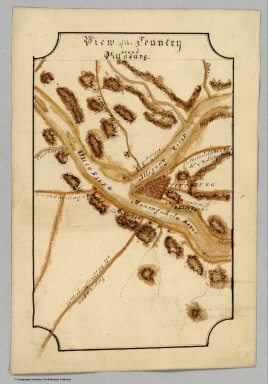 |
Eight manuscript maps: New York, Connecticut, New Hampshire, Delaware, Vermont, View of the Country ‘Round Pittsburg, View of the Country ‘Round Zanesville, East End of Lake Ontario, 1816
Bringhurst, William.
The state maps are dated 1816; the other three maps are undated. The Ontario, Pittsburgh and Zanesville maps are copied from similar maps that appear in Melish's "Geographical Description," most likely the 1820 or 22 edition because of the rounded corners which do not appear in the earlier editions of 1815 and 16. The state maps are copied from Scott's Gazetteer of 1795. The penmanship is very good. All maps in outline color. Relief shown by hachures and shadings. View Maps
|
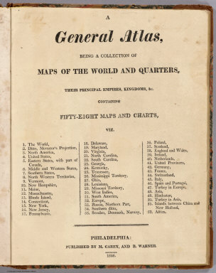 |
A General Atlas, Being A Collection Of Maps Of The World And Quarters, Their Principal Empires, Kingdoms, &c. Containing Fifty Eight Maps And Charts, 1816
Carey, Mathew; Warner, Benjamin, Philadelphia
The maps in this atlas result from a collaboration between Carey and Warner, using maps from their prior publications. This was probably published in a small edition and was an attempt to serve the market with a cheaper and smaller version of the folio General Atlas by Carey. This atlas is not listed in any of the references; we are aware of only four copies. View Atlas
|
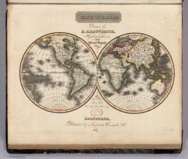 |
A New General Atlas, Constructed from the latest Authorities, By A. Arrowsmith, Hydrographer to the Prince Regent, Exhibiting The Boundaries And Divisions, Also The Chains of Mountains and other Geographical Features Of All The Known Countries In The World, 1817
Arrowsmith, Aaron, London
This is the first edition of Arrowsmith atlas published in 1817. Although the maps are not large, they are dense with information. This complete atlas features 53 copperplate maps, drawn by Arrowsmith and engraved by Sidney Hall, with a few engraved by Thomson in collaboration with Hall. View Atlas
|
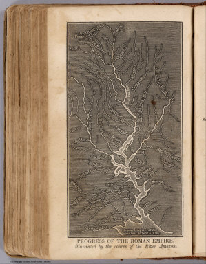 |
Ancient Geography, As Connected With Chronology, And Preparatory to the Study of Ancient History By Emma Willard (with) A System of Universal Geography, On The Principles of Comparison and Classification; By William Channing Woodbridge ... Illustrated With Maps and Engravings; And Accompanied by an Atlas, 1824
Willard, Emma, Hartford
Willard did not yet have an atlas to accompany her Ancient Geography - she first issued that atlas in 1827. Of particular interest is the plate "Progress Of The Roman Empire, Illustrated By The course Of The River Amazon" in which Willard uses the course of the Amazon and its tributaries to make a time chart of the Roman Empire. Woodbridge and Willard discovered that they shared similar approaches to teaching geography and so decided to collaborate on this book. View Book
|
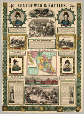 |
Twelve Broadsides and Maps Illustrating The U.S. Mexican War, 1846 to 1855
Various Publishers, Various Places
This groups of maps and broadsides show the progress and battles of the U.S. Mexican conflict and the aftermath. Several of the broadsides are highly decorative with maps, views, portraits, and tables of text. View Maps
|
 |
A New Map Of California, 1852
Gibbes, C.D., Stockton, California
Early state map, inaccurate yet elegant. Graphically, it is exceptionally well done. Wheat: "This was the most elaborate map of California that had yet appeared. It is beautifully designed and drawn, and includes a large number of the mining towns, though it cannot be entirely commended for accuracy." A portion of this map was published as Gibbes' New Map of the Gold Region in California, 1851, which was also issued in the Stockton Directory and Emigrant's Guide to the Southern Mines. View Map
|
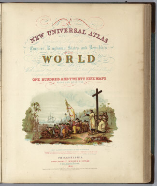 |
A New Universal Atlas Containing Maps of the various Empires, Kingdoms, States and Republics Of The World. With a special map of each of the United States, Plans of Cities &c. Comprehended in seventy five sheets and forming a series of One Hundred And Twenty Nine Maps, Plans And Sections, 1855
Mitchell, Samuel Augustus, Philadelphia
Early 1855 edition. Color lithographed title page. This copy belonged to Judah Chase (with his name gold stamped on the cover) who was a noted Blue Hill, Maine, Sea Captain and owner of the Brig Thomas M. Lyon. This ship sailed from Havre, France, at the end of March, 1836, and sank in a heavy gale off the Island of Jersey - but the crew was saved. The fine condition of this atlas suggests that it remained in Captain Chase's library and never went to sea. View Atlas
|
 |
Thirty Maritime Charts, 1800 to 1907
Various Publishers, Various Places
This group of sea charts ranges from the west coast of South America to Cape Cod to San Francisco Bay. Most are by the U.S. Coast Survey. View Charts
|
|
|
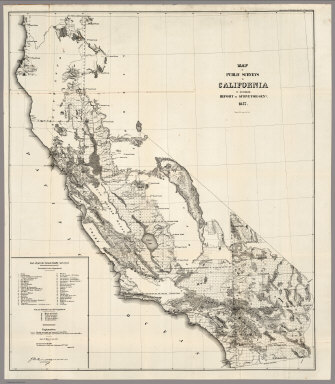
Thirty Seven Maps to Accompany the Reports of the General Land Office, 1951 to 1876
U.S. General Land Office, Washington D.C.
A group of very early General Land Office surveys showing Washington, Oregon, California, Idaho, New Mexico and the United States. View Maps
|
|
|
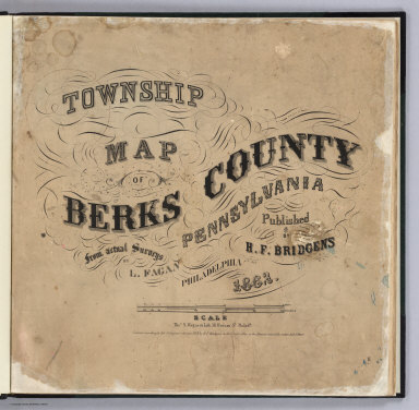
Ten United States County Atlases, 1862 to 1885
Various Publishers, Various Places
Includes the first county atlas published in the U.S., Berks County, Pennsylvania. Also, Lancaster County, Pennsylvania; Franklin County, Pennsylvania; Androscoggin County, Maine; Steuben County, New York; Saint John City and County, New Brunswick, Canada; Logan County, Ohio; Daviess County, Kentucky; Leavenworth County, Kansas; and Cedar County, Iowa. All include maps, views, directories, and other information considered useful at the time. View Atlases
|
|
|
Two Editions of Johnson's New Illustrated (Steel Plate) Family Atlas, With Physical Geography, And With Descriptions Geographical, Statistical, And Historical, 1864 and 1870
Johnson, A.J., New York
The 1864 and the 1870 editions of Johnson's world atlases, showing the United States during the U.S. Civil War and after it. View Atlases
|
|
|
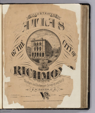
Illustrated Atlas Of The City Of Richmond, Va., 1876
Beers, F.W., No Place
A scarce atlas of Richmond a decade after the end of the Civil War. Wonderful detail on buildings and their owners, parks and public buildings. This copy is undated on the title page, but dated 1876 on the original front cover. A second edition was published in 1877. The index calls for seven views of Richmond that are not present in this copy and appear to never have been bound in, indicating that some copies were issued without the views (a common practice among the Beers). We have made two large composite maps of Richmond and Manchester. View Atlas
|
|

|
Royal Relief Atlas of All Parts of the World. Consisting of 31 Maps, With Physical, Political, and Statistical Descriptions facing each Map, 1880
Sonnenschein, W. Swan; Allen; Bevan, G.P., London
Raised relief maps. The maps are presented flat and a second copy with raised relief accomplished by embossing the paper. First edition, followed by editions in (1881) and 1885. Similar (perhaps copied from) to Woldermann's relief atlas in German. Phillips attributes this to G.P. Bevan. View Atlas
|
|
|
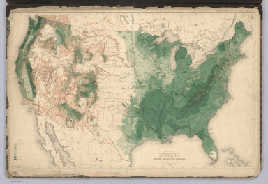
Department of the Interior, Census Office. Sixteen Maps Accompanying Report On Forest Trees Of North America, 1884
Sargent, C.S., New York
Loose in a folio. 10th census information. Show distribution of trees and types of trees. None of this information appears in any of the census atlases. Maps are printed in color and loose in plaid paper covered boards with cloth ties and a label printed with the above title. View Maps
|
|
|
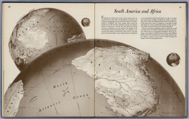
Atlas of Global Geography. 1944
Raisz, Erwin, New York
On the jacket it states that this is an "entirely new kind of atlas - A beautiful and informative book of 'global' maps, giving a plane's-eye view of tomorrow's geography..." Inside dust jacket's back cover: short biography of Dr. Edwin Raisz, Photo by Bacharch. Raisz perfected a unique style of hand drawn cartography that was a great contribution to 20th century cartography. More information about him may be found at www. raiszmaps.com. Maps in color. With paper dust jacket. View Atlas
|
|
|
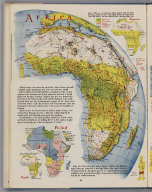
Look At The World: The Fortune Atlas For World Strategy, 1944
Harrison, Richard Edes, New York
Richard Harrison produced in this remarkable atlas a unique view of the world for the "air age." These maps are precursors of our ubiquitous satellite maps of today, yet hand drawn with great cartographic skill. View Atlas
|
|
|
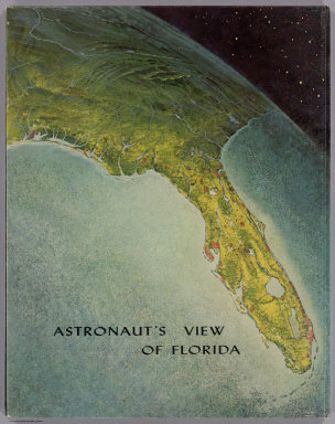
Atlas of Florida, 1964
Raisz, Erwin, Gainesville
Maps in full color, many thematic. Raisz perfected a unique style of hand drawn cartography that was a great contribution to 20th century cartography. More information about him may be found at www.raiszmaps.com At the back of the book is a fold-out road map of Florida. Covers are dark green marbled paper covered cardboard 36x27 with title "Atlas of Florida by Erwin Raisz and associates with text by John R. Dunkle. Prepared in the Department of Geography, University of Florida. University of Florida Press, Gainesville." View Atlas
|
Thank you for this site. It gives such detailed information.
Printing Company